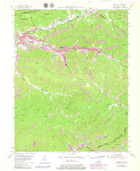
1954 Map of Benham
USGS Topo · Published 1979About this map
Benham and Lynch anchor this detailed study of the Appalachian coal country in Harlan County, where industrial development follows the narrow valley of Looney Creek. During the mid-twentieth century, the L & N railroad served as the primary corridor for commerce and community life, connecting settlements like Louisville and Clutts along the steep slopes of Looney Ridge. The map documents a landscape defined by intensive resource extraction and remote mountain geography, with contours in strip mine areas updated through the late 1970s. Local history is preserved in the locations of the Creech Cem and Coldiron Sch, while the peaks of Black Mountain and Pine Mountain enclose the drainage basins of the Poor Fork Cumberland River. From the Lookout Tower on Benham Spur to the boundary at Kentucky Virginia, the sheet illustrates the era's reliance on mountain passes and ridgeline trails.
Find a feature on this map
41 named features on this map. Tap any name to fly to it.
Don’t see what you’re looking for? This feature index may not catch every label — zoom into the map to look around manually.
Map Details
Editions of this 1954 Benham Map
4 editions found
Other maps of this area

1887 · Jonesville
USGS Topo · 1:125,000

1890 · Whitesburg
USGS Topo · 1:125,000

1891 · Hazard
USGS Topo · 1:125,000

1891 · Jonesville
USGS Topo · 1:125,000

1892 · Whitesburg
USGS Topo · 1:125,000

1894 · Estillville
USGS Topo · 1:125,000

1913 · Oven Fork
USGS Topo · 1:48,000

1915 · Whitesburg
USGS Topo · 1:62,500

1916 · Cornettsville
USGS Topo · 1:62,500

1916 · Nolansburg
USGS Topo · 1:48,000