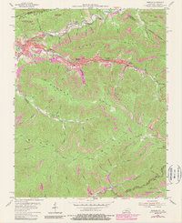
1954 Map of Benham
USGS Topo · Published 1990About this map
Benham and Lynch serve as the industrial anchors of this Harlan County landscape, where the coal-driven economy of the mid-20th century is etched into the narrow valleys. The Louisville and Nashville railroad winds through the heart of these settlements, following the course of Looney Creek and connecting the mines to broader markets. On the hillsides above the residential clusters, purple photo-revisions from the late 1970s indicate the expansion of strip mining operations, contrasting with the preserved ridge lines of Kingdom Come State Park and Jefferson National Forest. Educational and social hubs like Lynch High Sch and Collyiron Sch are clearly marked, alongside various family and community cemeteries. The rugged topography is defined by the massive silhouettes of Pine Mountain and Black Mountain, which wall in the Poor Fork Cumberland River.
Find a feature on this map
86 named features on this map. Tap any name to fly to it.
Don’t see what you’re looking for? This feature index may not catch every label — zoom into the map to look around manually.
Map Details
Editions of this 1954 Benham Map
4 editions found
Other maps of this area

1887 · Jonesville
USGS Topo · 1:125,000

1890 · Whitesburg
USGS Topo · 1:125,000

1891 · Hazard
USGS Topo · 1:125,000

1891 · Jonesville
USGS Topo · 1:125,000

1892 · Whitesburg
USGS Topo · 1:125,000

1894 · Estillville
USGS Topo · 1:125,000

1913 · Oven Fork
USGS Topo · 1:48,000

1915 · Whitesburg
USGS Topo · 1:62,500

1916 · Cornettsville
USGS Topo · 1:62,500

1916 · Nolansburg
USGS Topo · 1:48,000