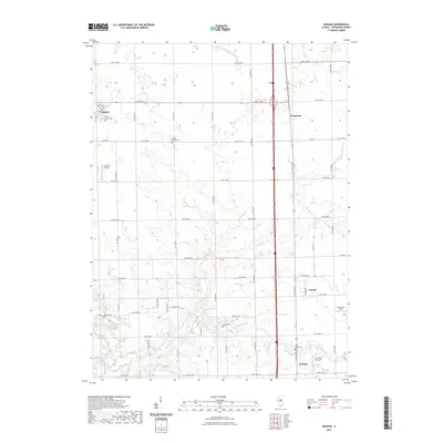
2021 Map of Benson
USGS Topo · Published 2021About this map
Benson and the northern outskirts of El Paso anchor this Woodford County landscape, where the prairie is defined by a rigid grid of agricultural roads and the winding path of Panther Cr. The map captures a quintessential Illinois farming district, punctuated by small settlements like Panola and Woodford. Local history is deeply embedded in the land through numerous rural burial grounds, including Saint Johns Cem and the Clayton Baptist Cem. The drainage patterns of the W Br Panther Cr and E Br Panther Cr create subtle breaks in the otherwise uniform sections. A unique aerial character is visible here, with three distinct private airstrips—Unzicker Airport, Barnstorm Field, and Corn Alley 2 Airport—scattered among the fields, reflecting the intersection of local aviation and the sprawling township and range system.
Find a feature on this map
52 named features on this map. Tap any name to fly to it.
Don’t see what you’re looking for? This feature index may not catch every label — zoom into the map to look around manually.
Map Details
Editions of this 2021 Benson Map
This is the sole edition of this map. No revisions or reprints were ever made.
Other maps of this area

1926 · Normal
USGS Topo · 1:62,500

1927 · Danvers
USGS Topo · 1:62,500

1930 · Danvers
USGS Topo · 1:62,500

1930 · Normal
USGS Topo · 1:62,500

1955 · Minonk
USGS Topo · 1:62,500

1958 · Flanagan
USGS Topo · 1:62,500

1958 · Peoria
USGS Topo · 1:250,000

1961 · Peoria
USGS Topo · 1:250,000

1963 · Peoria
USGS Topo · 1:250,000
1970 · Secor
USGS Topo · 1:24,000