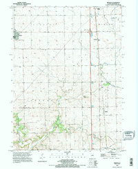
1995 Map of Benson
USGS Topo · Published 1996About this map
Benson and the surrounding townships of Clayton and Greene appear here during a period of late-twentieth-century stability in north-central Illinois. The landscape is defined by the headwaters of Panther Creek, with its West Branch and East Branch carving subtle drainage patterns across the agricultural prairie. Small nodes of settlement like Panola and Woodford are situated along the transportation corridors that bisect the region, including the modern Interchange 22 which contrasts with the older town-site layouts.
Find a feature on this map
28 named features on this map. Tap any name to fly to it.
Don’t see what you’re looking for? This feature index may not catch every label — zoom into the map to look around manually.
Map Details
Editions of this 1995 Benson Map
This is the sole edition of this map. No revisions or reprints were ever made.
Other maps of this area

1926 · Normal
USGS Topo · 1:62,500

1927 · Danvers
USGS Topo · 1:62,500

1930 · Danvers
USGS Topo · 1:62,500

1930 · Normal
USGS Topo · 1:62,500

1955 · Minonk
USGS Topo · 1:62,500

1958 · Flanagan
USGS Topo · 1:62,500

1958 · Peoria
USGS Topo · 1:250,000

1961 · Peoria
USGS Topo · 1:250,000

1963 · Peoria
USGS Topo · 1:250,000
1970 · Secor
USGS Topo · 1:24,000