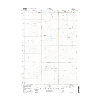
2014 Map of Bentley
USGS Topo · Published 2014About this map
Bentley and Rhodes serve as the primary hubs in this rural landscape, which sits along the border of Gladwin, Bay, and Arenac counties. The area is defined by its complex hydrology, featuring the Little Molasses River and the expansive Molasses River Flooding Number Three, alongside local waterways like Saganing Creek and Fish Creek. These water features, coupled with drainage systems like Gear Drain and Chubb Drain, illustrate a landscape managed for water control and agricultural utility. Local history is anchored by several burial grounds, including Bentley Cemetery and a cluster of sites further south near Rhodes, such as Rhodes Cemetery, New Rhodes Cemetery, and Hope Lutheran Cemetery. The road network follows a rigid grid, from the state highway M-61 to family-named routes like Klender Road and Westenfeld Road, reflecting a long-standing settlement pattern within the Michigan townships.
Find a feature on this map
44 named features on this map. Tap any name to fly to it.
Don’t see what you’re looking for? This feature index may not catch every label — zoom into the map to look around manually.
Map Details
Editions of this 2014 Bentley Map
This is the sole edition of this map. No revisions or reprints were ever made.
Other maps of this area

1954 · Traverse City
USGS Topo · 1:250,000

1954 · Midland
USGS Topo · 1:250,000

1958 · Traverse City
USGS Topo · 1:250,000

1958 · Midland
USGS Topo · 1:250,000

1959 · Midland
USGS Topo · 1:250,000

1966 · Midland
USGS Topo · 1:250,000
1967 · Mount Forest
USGS Topo · 1:24,000
1967 · Crump
USGS Topo · 1:24,000

1968 · Sterling
USGS Topo · 1:24,000

1968 · Sterling SW
USGS Topo · 1:24,000