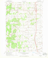
1967 Map of Crump
USGS Topo · Published 1969About this map
Mount Forest and Pinconning townships define the northern half of this landscape, where the Pinconning River and its various branches create a complex drainage network alongside named channels like the Johnson Drain. The southern portion is marked by the agricultural communities of Crump and Bryce, showing the organized grid of section roads and the transition from wooded tracts to cleared fields. Local social life is anchored by rural institutions such as the Garfield-Fraser Sch and several country churches including St Marys Ch and Garfield Ch.
Find a feature on this map
44 named features on this map. Tap any name to fly to it.
Don’t see what you’re looking for? This feature index may not catch every label — zoom into the map to look around manually.
Map Details
Editions of this 1967 Crump Map
2 editions found
Other maps of this area

1916 · Bay City
USGS Topo · 1:62,500

1919 · Bay City
USGS Topo · 1:62,500

1943 · Bay City
USGS Topo · 1:62,500

1954 · Midland
USGS Topo · 1:250,000

1954 · Flint
USGS Topo · 1:250,000

1958 · Flint
USGS Topo · 1:250,000

1958 · Midland
USGS Topo · 1:250,000

1959 · Midland
USGS Topo · 1:250,000

1962 · Willard
USGS Topo · 1:24,000

1962 · Midland North
USGS Topo · 1:24,000