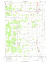
1967 Map of Crump
USGS Topo · Published 1974About this map
Penn Central rail lines and the busy corridor of Interstate 75 bisect this section of Bay County, marking a period of significant infrastructure development. The landscape is defined by an intricate network of agricultural drainage, including the Pinconning River, Johnson Drain, and Erickson Drain, which support the rural farmsteads of Mount Forest, Pinconning, and Garfield townships. Small community hubs like Woodville, Willard, and Crump anchor the local road grid.
Find a feature on this map
49 named features on this map. Tap any name to fly to it.
Don’t see what you’re looking for? This feature index may not catch every label — zoom into the map to look around manually.
Map Details
Editions of this 1967 Crump Map
2 editions found
Other maps of this area

1916 · Bay City
USGS Topo · 1:62,500

1919 · Bay City
USGS Topo · 1:62,500

1943 · Bay City
USGS Topo · 1:62,500

1954 · Midland
USGS Topo · 1:250,000

1954 · Flint
USGS Topo · 1:250,000

1958 · Flint
USGS Topo · 1:250,000

1958 · Midland
USGS Topo · 1:250,000

1959 · Midland
USGS Topo · 1:250,000

1962 · Willard
USGS Topo · 1:24,000

1962 · Midland North
USGS Topo · 1:24,000