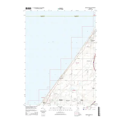
2014 Map of Benton Heights
USGS Topo · Published 2014About this map
Benton Harbor and its surrounding coastal communities are captured here along the eastern edge of Lake Michigan. The landscape is defined by the winding course of the Paw Paw River, which flows through the southern portion of the map near Benton Heights and the Southwest Michigan Regional Airport. The shoreline is dotted with established residential pockets and resorts, including Higman Park, Mizpah Park, and Lake Michigan Beach to the north. Moving inland, the terrain transitions into a more rural grid characterized by small settlements like Riverside and Twelve Corners. Researchers will find a mix of early 21st-century infrastructure and long-standing local landmarks, such as N Shore Memory Garden and Lake Shore Cem, alongside a network of drainage features like Granger Drain and Blue Cr that support the region's agricultural and suburban development.
Find a feature on this map
51 named features on this map. Tap any name to fly to it.
Don’t see what you’re looking for? This feature index may not catch every label — zoom into the map to look around manually.
Map Details
Editions of this 2014 Benton Heights Map
This is the sole edition of this map. No revisions or reprints were ever made.
Other maps of this area

1927 · Benton Harbor
USGS Topo · 1:62,500

1927 · South Haven
USGS Topo · 1:62,500

1930 · South Haven
USGS Topo · 1:62,500

1930 · Benton Harbor
USGS Topo · 1:62,500

1943 · South Haven
USGS Topo · 1:62,500

1958 · Racine
USGS Topo · 1:250,000

1962 · Racine
USGS Topo · 1:250,000
1970 · Coloma
USGS Topo · 1:24,000
1970 · Benton Harbor
USGS Topo · 1:24,000
1970 · Sodus
USGS Topo · 1:24,000