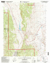
1994 Map of Benton Hot Springs
USGS Topo · Published 1997About this map
Benton Hot Springs serves as the focal point of this high-desert basin, where geothermal activity and mining history intersect at the edge of the Benton Range. The settlement, complete with a local Cem, sits at the mouth of Blind Spring Valley, a landscape defined by its extractive industry as evidenced by numerous prospects and specialized Pumice Quarries. To the west, the arid expanse of Adobe Valley contains Black Lake, a significant water feature in this rain-shadow environment. The terrain rises sharply toward Lake Mountain and the high ridges of the Inyo National Forest, where deep incisions like Kelty Canyon and Klondike Canyon reveal the complex geology of the Eastern Sierra foothills. Evidence of early cattle ranching or freighting appears in labels for a Corral and Dutch along the valley floor, while a remote Mine Shaft near Watterson Meadow speaks to the region's isolated prospecting efforts.
Find a feature on this map
31 named features on this map. Tap any name to fly to it.
Don’t see what you’re looking for? This feature index may not catch every label — zoom into the map to look around manually.
Map Details
Editions of this 1994 Benton Hot Springs Map
2 editions found
Other maps of this area

1914 · Mt. Morrison
USGS Topo · 1:125,000

1917 · White Mountain
USGS Topo · 1:125,000

1947 · Mariposa
USGS Topo · 1:250,000

1948 · Mariposa
USGS Topo · 1:250,000

1953 · Casa Diablo Mtn
USGS Topo · 1:62,500

1957 · Mariposa
USGS Topo · 1:250,000

1962 · Benton
USGS Topo · 1:62,500

1962 · Glass Mountain
USGS Topo · 1:62,500

1962 · White Mtn. Peak
USGS Topo · 1:62,500

1963 · Mariposa
USGS Topo · 1:250,000