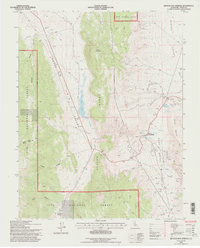
1994 Map of Benton Hot Springs
USGS Topo · Published 1997About this map
Benton Hot Springs lies at the intersection of high-desert basins and mountain ranges, serving as a focal point for this eastern California landscape. The area is defined by the high elevations of the Benton Range and Trafton Mountain, which separate the expansive Adobe Valley from Benton Valley. Evidence of the region's geological utility is scattered throughout, from the Pumice Quarries in the northeast to a remote Mine Shaft and numerous Prospects in the foothills.
Find a feature on this map
40 named features on this map. Tap any name to fly to it.
Don’t see what you’re looking for? This feature index may not catch every label — zoom into the map to look around manually.
Map Details
Editions of this 1994 Benton Hot Springs Map
2 editions found
Other maps of this area

1914 · Mt. Morrison
USGS Topo · 1:125,000

1917 · White Mountain
USGS Topo · 1:125,000

1947 · Mariposa
USGS Topo · 1:250,000

1948 · Mariposa
USGS Topo · 1:250,000

1953 · Casa Diablo Mtn
USGS Topo · 1:62,500

1957 · Mariposa
USGS Topo · 1:250,000

1962 · Benton
USGS Topo · 1:62,500

1962 · Glass Mountain
USGS Topo · 1:62,500

1962 · White Mtn. Peak
USGS Topo · 1:62,500

1963 · Mariposa
USGS Topo · 1:250,000