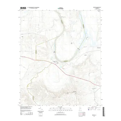
2014 Map of Benton
USGS Topo · Published 2014About this map
The Alabama River carves a winding course through the heart of this landscape at the intersection of Dallas, Lowndes, and Autauga counties. Along its banks, the settlement of Benton serves as a focal point, where Us-80 crosses the terrain near B C Rhyne Lake. The map reveals a rural community structure defined by small settlements and family burial grounds, including the Robert Rives Cem and Mt Gilead Cem near White Hall. These landmarks, along with Petronia and the sweeping curve of Days Bend, illustrate a landscape where the river remains the primary geographic anchor. Further inland, the drainage patterns of Old Town Cr and Pilot Cr navigate the contours of the Alabama Black Belt, a region traditionally defined by its rich agricultural history and dispersed crossroads communities like Tyler and Edsons.
Find a feature on this map
43 named features on this map. Tap any name to fly to it.
Don’t see what you’re looking for? This feature index may not catch every label — zoom into the map to look around manually.
Map Details
Editions of this 2014 Benton Map
This is the sole edition of this map. No revisions or reprints were ever made.
Other maps of this area

1953 · Montgomery
USGS Topo · 1:250,000

1956 · Montgomery
USGS Topo · 1:250,000

1957 · Montgomery
USGS Topo · 1:250,000

1957 · Autaugaville
USGS Topo · 1:62,500

1957 · Benton
USGS Topo · 1:62,500

1957 · Braggs
USGS Topo · 1:62,500

1975 · Benton SE
USGS Topo · 1:24,000

1975 · Autaugaville SW
USGS Topo · 1:24,000
1975 · Benton NE
USGS Topo · 1:24,000
1975 · Benton SW
USGS Topo · 1:24,000