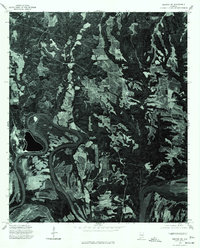
1975 Map of Benton NE
USGS Topo · Published 1977About this map
The Alabama River winds through this 1975 aerial perspective of Autauga County, carving deep meanders across the landscape south of Mulberry. This orthophotoquad provides a clear view of the rural patterns of the mid-1970s, where traditional agricultural clearings contrast sharply with dense woodland and the oxbow formations of the river valley. The imagery reveals the relationship between the elevated plateau settlements and the dynamic watercourse, showing the specific land use and field boundaries as they existed during this era of Alabama's history.
Find a feature on this map
2 named features on this map. Tap any name to fly to it.
Don’t see what you’re looking for? This feature index may not catch every label — zoom into the map to look around manually.
Map Details
Editions of this 1975 Benton NE Map
This is the sole edition of this map. No revisions or reprints were ever made.
Other maps of this area

1891 · Clanton
USGS Topo · 1:125,000

1953 · Montgomery
USGS Topo · 1:250,000

1956 · Montgomery
USGS Topo · 1:250,000

1957 · Montgomery
USGS Topo · 1:250,000

1957 · Autaugaville
USGS Topo · 1:62,500

1957 · Benton
USGS Topo · 1:62,500

1959 · Plantersville
USGS Topo · 1:62,500

1959 · Billingsley
USGS Topo · 1:62,500

1975 · Benton SE
USGS Topo · 1:24,000

1975 · Autaugaville SW
USGS Topo · 1:24,000