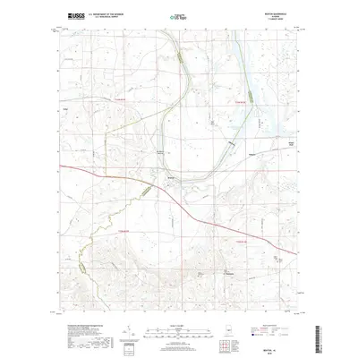
2018 Map of Benton
USGS Topo · Published 2018About this map
The Alabama River meanders through the heart of this landscape, defining the boundaries where Dallas, Autauga, and Lowndes Counties meet. The settlement of Benton sits on the southern bank, positioned near the confluence of Old Town Cr and the main river channel. This area is characterized by significant riverine features like Days Bend and the R E 'Bob' Woodruff Reservoir, illustrating the managed waterway system of modern Alabama.
Find a feature on this map
46 named features on this map. Tap any name to fly to it.
Don’t see what you’re looking for? This feature index may not catch every label — zoom into the map to look around manually.
Map Details
Editions of this 2018 Benton Map
This is the sole edition of this map. No revisions or reprints were ever made.
Other maps of this area

1953 · Montgomery
USGS Topo · 1:250,000

1956 · Montgomery
USGS Topo · 1:250,000

1957 · Montgomery
USGS Topo · 1:250,000

1957 · Autaugaville
USGS Topo · 1:62,500

1957 · Benton
USGS Topo · 1:62,500

1957 · Braggs
USGS Topo · 1:62,500

1975 · Benton SE
USGS Topo · 1:24,000

1975 · Autaugaville SW
USGS Topo · 1:24,000
1975 · Benton NE
USGS Topo · 1:24,000
1975 · Benton SW
USGS Topo · 1:24,000