Loading...
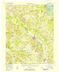
Loading map...1955 Map of Benton
USGS Topo · Published 1957About this map
Benton serves as the central hub of this mid-century survey, situated at the confluence of several branches of the East Fork Clarks River. To the northeast, the massive impoundment of Kentucky Lake and the engineering of the Kentucky Dam mark a landscape transformed by the U.S. Tennessee Valley Authority. The map details a transition from the river-bottom agriculture and timber of Steam Mill Bend to the developing recreational infrastructure at Kentucky Dam Village State Park.
Find a feature on this map
104 named features on this map. Tap any name to fly to it.
Don’t see what you’re looking for? This feature index may not catch every label — zoom into the map to look around manually.
Map Details
Date Portrayed1955
Date Published1957
PublisherU.S. Geological Survey
Map TypeTopographic
Scale1:62,500
Physical Dimensions17.5 x 21.4 inches
Editions of this 1955 Benton Map
This is the sole edition of this map. No revisions or reprints were ever made.
Historical Maps of Benton Through Time

Featured Locations
Source Details
SourceU.S. Geological Survey
CopyrightPublic Domain