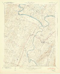
1940 Map of Benton
USGS Topo · Published 1940About this map
Benton serves as the focal point of this 1940 survey, situated where the Ocoee River and Hiwassee River converge amidst a landscape of river bottoms and rising peaks. The map details the local economy and social structure of the era through its dense network of rural infrastructure, including Chestuee Mills and the Old Wilson Mill. Local families can be traced through sites like the Baker Chapel Cem and Pursley Cem, while community life is anchored by numerous small congregations such as Mt Hermon Ch and Pleasant Grove Ch. The influence of the Tennessee Valley Authority is evident in the inclusion of the Chickamauga Res elevation, reflecting a period of significant hydraulic and geographical transformation. Transportation is dominated by the Louisville and Nashville railroad and landmarks like Reynolds Bridge, which facilitated movement across the complex river bends like Pinhook Bend and Calhoun Bend.
Find a feature on this map
104 named features on this map. Tap any name to fly to it.
Don’t see what you’re looking for? This feature index may not catch every label — zoom into the map to look around manually.
Map Details
Editions of this 1940 Benton Map
3 editions found
Other maps of this area

1886 · Cleveland
USGS Topo · 1:125,000

1892 · Cleveland
USGS Topo · 1:125,000

1895 · Cleveland
USGS Topo · 1:125,000

1901 · Cleveland
USGS Topo · 1:125,000

1935 · East Cleveland
USGS Topo · 1:24,000

1935 · Calhoun
USGS Topo · 1:24,000

1935 · Benton
USGS Topo · 1:24,000

1935 · Felker
USGS Topo · 1:24,000

1935 · Charleston
USGS Topo · 1:24,000
1935 · Parksville
USGS Topo · 1:24,000