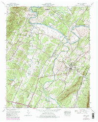
1967 Map of Benton
USGS Topo · Published 1977About this map
The Hiwassee River and Ocoee River define the fertile bottomlands of this Polk County landscape, which by the mid-1960s was transitioning into the modern era of the Tennessee Valley Authority’s water management. The town of Benton serves as a focal point, situated between the high ridges of Chestuee Mountain and the sweeping curves of the river. A significant historical landmark is the Nancy Ward Cem, marking the final resting place of the Cherokee Beloved Woman, which reflects the deep indigenous and early frontier roots of the region.
Find a feature on this map
79 named features on this map. Tap any name to fly to it.
Don’t see what you’re looking for? This feature index may not catch every label — zoom into the map to look around manually.
Map Details
Editions of this 1967 Benton Map
3 editions found
Other maps of this area

1886 · Cleveland
USGS Topo · 1:125,000

1892 · Cleveland
USGS Topo · 1:125,000

1895 · Cleveland
USGS Topo · 1:125,000

1901 · Cleveland
USGS Topo · 1:125,000

1935 · East Cleveland
USGS Topo · 1:24,000

1935 · Calhoun
USGS Topo · 1:24,000

1935 · Benton
USGS Topo · 1:24,000

1935 · Felker
USGS Topo · 1:24,000

1935 · Charleston
USGS Topo · 1:24,000
1935 · Parksville
USGS Topo · 1:24,000