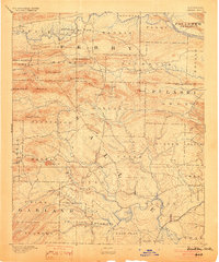
1894 Map of Benton
USGS Topo · Published 1903About this map
The Saline River and the Benton townsite anchor the southern reaches of this landscape, surveyed in the late 19th century. This region is defined by the complex drainage systems between the Arkansas River to the north and the Saline to the south, featuring a network of vital waterways like the Fourche La Fave River and the Maumelle River. Smaller settlements such as Aplin, Brazils, and Avilla serve as early markers of community growth during this period of settlement. The terrain is notably punctuated by distinctive peaks including the Maumelle Pinnacles, Shinall Mt, and Flatside Pinnacle, which shaped the early paths and township boundaries through Pulaski and Saline counties. Local family names and geography appear in labels like Frilliman Ridge and Henderson Creek, providing valuable touchpoints for genealogists and researchers tracking the rural development of central Arkansas.
Find a feature on this map
62 named features on this map. Tap any name to fly to it.
Don’t see what you’re looking for? This feature index may not catch every label — zoom into the map to look around manually.
Map Details
Editions of this 1894 Benton Map
5 editions found

Other maps of this area

1888 · Dardanelle #4
USGS Topo · 1:62,500

1889 · Morrilton No. 3
USGS Topo · 1:62,500

1890 · Benton
USGS Topo · 1:125,000

1890 · Hot Springs
USGS Topo · 1:125,000

1890 · Dardanelle
USGS Topo · 1:125,000

1891 · Little Rock
USGS Topo · 1:125,000

1892 · Morrillton
USGS Topo · 1:125,000

1893 · Little Rock
USGS Topo · 1:125,000

1894 · Morrillton
USGS Topo · 1:125,000

1894 · Hot Springs
USGS Topo · 1:125,000