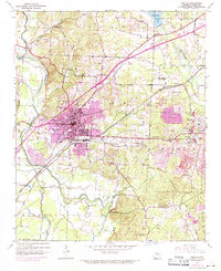
1944 Map of Benton
USGS Topo · Published 1971About this map
The Saline River and its North Fork anchor this mid-century survey of Saline County, documenting the industrial and municipal growth around Benton. This 1970 revision overlays a 1944 base, highlighting urban expansion and the development of the Saline County Airport. The landscape is a mix of traditional community centers and heavy industry, most notably at the aluminum-focused settlement of Bauxite, where Open Pit Mines and Tailings Ponds dominate the eastern topography.
Find a feature on this map
41 named features on this map. Tap any name to fly to it.
Don’t see what you’re looking for? This feature index may not catch every label — zoom into the map to look around manually.
Map Details
Editions of this 1944 Benton Map
4 editions found

Other maps of this area

1890 · Benton
USGS Topo · 1:125,000

1891 · Little Rock
USGS Topo · 1:125,000

1893 · Little Rock
USGS Topo · 1:125,000

1894 · Benton
USGS Topo · 1:125,000

1935 · Alexander
USGS Topo · 1:48,000

1938 · Benton
USGS Topo · 1:48,000

1941 · Alexander
USGS Topo · 1:62,500

1944 · Benton
USGS Topo · 1:62,500

1944 · Alexander
USGS Topo · 1:31,680

1944 · Bryant
USGS Topo · 1:31,680