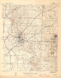
1944 Map of Benton
USGS Topo · Published 1946About this map
Benton serves as the central hub of this 1944 survey, where the convergence of the Missouri Pacific and the Chicago Rock Island And Pacific railroads drives the local economy. The landscape is heavily marked by the industrial footprints of Bauxite and Pine Haven to the east, reflecting the area's significance in mineral extraction during the mid-1940s. Beyond the tracks, the terrain is defined by the winding Saline River and its tributaries, including Salt Creek and Hurricane Creek.
Find a feature on this map
45 named features on this map. Tap any name to fly to it.
Don’t see what you’re looking for? This feature index may not catch every label — zoom into the map to look around manually.
Map Details
Editions of this 1944 Benton Map
4 editions found

Other maps of this area

1890 · Benton
USGS Topo · 1:125,000

1891 · Little Rock
USGS Topo · 1:125,000

1893 · Little Rock
USGS Topo · 1:125,000

1894 · Benton
USGS Topo · 1:125,000

1935 · Alexander
USGS Topo · 1:48,000

1938 · Benton
USGS Topo · 1:48,000

1941 · Alexander
USGS Topo · 1:62,500

1944 · Benton
USGS Topo · 1:62,500

1944 · Alexander
USGS Topo · 1:31,680

1944 · Bryant
USGS Topo · 1:31,680