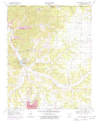
1970 Map of Bentonville North
USGS Topo · Published 1977About this map
The growing northern edge of Bentonville and the early planned recreation of Bella Vista anchor this 1970s topographical portrait of northwest Arkansas. The map details a landscape in transition, where the street grid of the Bentonville corporate boundary meets the surrounding rural terrain of Osage and Mount Vernon. Notable local landmarks like Bates Memorial Hospital and the Thomas Jefferson Sch are clearly marked, alongside the industrial footprint of a Sewage Disposal plant and several gravel pits.
Find a feature on this map
42 named features on this map. Tap any name to fly to it.
Don’t see what you’re looking for? This feature index may not catch every label — zoom into the map to look around manually.
Map Details
Editions of this 1970 Bentonville North Map
4 editions found
Other maps of this area

1899 · Fayetteville
USGS Topo · 1:125,000

1901 · Fayetteville
USGS Topo · 1:125,000

1904 · Fayetteville
USGS Topo · 1:125,000

1940 · Noel
USGS Topo · 1:62,500

1941 · Rocky Comfort
USGS Topo · 1:62,500

1943 · Noel
USGS Topo · 1:62,500

1943 · Rocky Comfort
USGS Topo · 1:62,500

1954 · Tulsa
USGS Topo · 1:250,000

1958 · Rogers
USGS Topo · 1:24,000

1958 · Pea Ridge
USGS Topo · 1:24,000