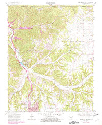
1970 Map of Bentonville North
USGS Topo · Published 1982About this map
Little Sugar Creek carves a deep valley through this corner of Northwest Arkansas, serving as the primary geographic corridor for the growing community of Bella Vista. By the late 1960s and early 1970s, the landscape was transitioning from rural farmsteads to a series of recreational reservoirs, including Lake Norwood, Lake Ann, and Lake Rayburn. These newer developments contrast with the established rural markers found in the east, such as the Shady Grove Community Hall and the settlement at Blackjack Corner.
Find a feature on this map
46 named features on this map. Tap any name to fly to it.
Don’t see what you’re looking for? This feature index may not catch every label — zoom into the map to look around manually.
Map Details
Editions of this 1970 Bentonville North Map
4 editions found
Other maps of this area

1899 · Fayetteville
USGS Topo · 1:125,000

1901 · Fayetteville
USGS Topo · 1:125,000

1904 · Fayetteville
USGS Topo · 1:125,000

1940 · Noel
USGS Topo · 1:62,500

1941 · Rocky Comfort
USGS Topo · 1:62,500

1943 · Noel
USGS Topo · 1:62,500

1943 · Rocky Comfort
USGS Topo · 1:62,500

1954 · Tulsa
USGS Topo · 1:250,000

1958 · Rogers
USGS Topo · 1:24,000

1958 · Pea Ridge
USGS Topo · 1:24,000