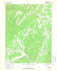
1967 Map of Bergton
USGS Topo · Published 1969About this map
Bergton sits at the confluence of the North Fork Shenandoah River and Crab Run, serving as a central hub for this valley in the late 1960s. The settlement is home to the Bergton School, the Bergton Gospel Center, and the nearby Martin Luther Church. The landscape is defined by the sharp ridges of the George Washington National Forest, including South Fork Mountain and Flat Top Mountain. This 1967 field-checked survey highlights the area's geological and industrial character with several gas wells and the pipelines that traverse the gaps between Lost River Mountain and Bush Mountain. Water is central to local geography, from the Blue Hole on the Shenandoah to the numerous runs that feed the Lost River and German River, illustrating a community deeply connected to its creek-side topography.
Find a feature on this map
59 named features on this map. Tap any name to fly to it.
Don’t see what you’re looking for? This feature index may not catch every label — zoom into the map to look around manually.
Map Details
Editions of this 1967 Bergton Map
4 editions found
Other maps of this area

1892 · Franklin
USGS Topo · 1:125,000

1892 · Woodstock
USGS Topo · 1:125,000

1896 · Franklin
USGS Topo · 1:125,000

1920 · Petersburg
USGS Topo · 1:48,000

1921 · Orkney Springs
USGS Topo · 1:48,000

1921 · Petersburg
USGS Topo · 1:48,000

1922 · Fort Seybert
USGS Topo · 1:48,000

1922 · Petersburg
USGS Topo · 1:62,500

1923 · Orkney Springs
USGS Topo · 1:62,500

1924 · Fort Seybert
USGS Topo · 1:62,500