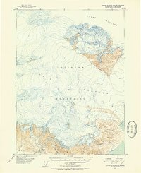
1951 Map of Bering Glacier A-2
USGS Topo · Published 1952About this map
Guyot Glacier dominates this mid-century Alaskan landscape, its massive expanse flowing through the Robinson Mountains toward the coast. The mapping, based on aerial photography taken in late 1948, captures a wild glacial system before the rapid environmental shifts of the later twentieth century. Along the southern margin, a network of drainage systems including Big River, Priest River, and Independence Creek snake toward the waters of Icy Bay. This transition from high ice fields to the tidal influences of the bay creates a complex terrain of unnamed peaks and precisely surveyed glacial contours. The proximity of Bear Glacier to the coastal flats near Big Sandy Creek illustrates the direct connection between the high mountain ice and the coastal hydrology of the Yakutat region during this era of early post-war topographical study.
Find a feature on this map
11 named features on this map. Tap any name to fly to it.
Don’t see what you’re looking for? This feature index may not catch every label — zoom into the map to look around manually.
Map Details
Editions of this 1951 Bering Glacier A-2 Map
3 editions found
Other maps of this area

1948 · Icy Bay D-2 and D-3
USGS Topo · 1:63,360

1950 · Bering Glacier A-3
USGS Topo · 1:63,360

1950 · Bering Glacier
USGS Topo · 1:250,000

1950 · Icy Bay
USGS Topo · 1:250,000

1951 · Icy Bay D-2 and D-3
USGS Topo · 1:63,360

1951 · Icy Bay
USGS Topo · 1:250,000

1951 · Bering Glacier
USGS Topo · 1:250,000

1951 · Bering Glacier A-2
USGS Topo · 1:63,360
1959 · Icy Bay D-2 and D-3
USGS Topo · 1:63,360

1959 · Bering Glacier
USGS Topo · 1:250,000