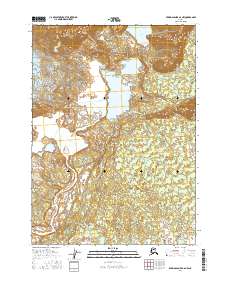
2016 Map of Bering Glacier A-6 NW
USGS Topo · Published 2016About this map
The massive icy reach of the Bering Glacier dominates the upper northwestern corner of this landscape, its presence shaping a complex drainage network into the southern coastal plain. The central portion of the sheet is defined by the Hanna Lake and the aptly named Abandoned River, illustrating a dynamic hydrological environment where glacial retreat and sediment deposit continuously alter the flow of water. To the south, the Tsivat River system branches into the E Fork Tsivat River and W Fork Tsivat River, winding through low-lying marshlands dotted with unique landforms like Weeping Peat Island and Bentwood Island. High ground persists at the margins, anchored by the Grindle Hills and Donald Ridge, which provide topographical contrast to the saturated delta and lake systems below.
Find a feature on this map
18 named features on this map. Tap any name to fly to it.
Don’t see what you’re looking for? This feature index may not catch every label — zoom into the map to look around manually.
Map Details
Editions of this 2016 Bering Glacier A-6 NW Map
This is the sole edition of this map. No revisions or reprints were ever made.
Other maps of this area

1950 · Bering Glacier
USGS Topo · 1:250,000

1951 · Bering Glacier
USGS Topo · 1:250,000

1959 · Bering Glacier
USGS Topo · 1:250,000
1984 · Bering Glacier A-6
USGS Topo · 1:63,360
1984 · Bering Glacier A-7
USGS Topo · 1:63,360
1985 · Bering Glacier B-6
USGS Topo · 1:63,360
1985 · Bering Glacier B-7
USGS Topo · 1:63,360
2016 · Bering Glacier A-6 NE
USGS Topo · 1:25,000
2016 · Bering Glacier B-7 SE
USGS Topo · 1:25,000
2016 · Bering Glacier A-7 NE
USGS Topo · 1:25,000