
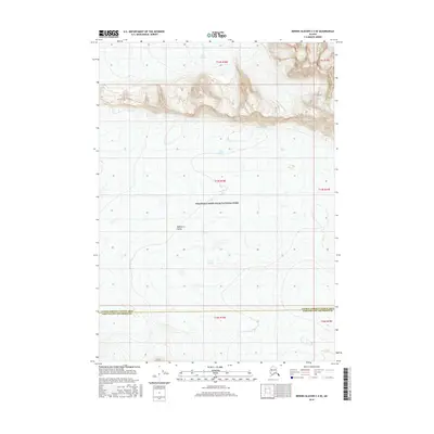
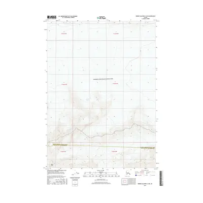
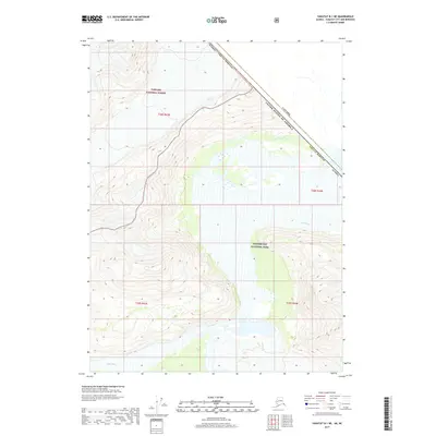
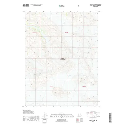
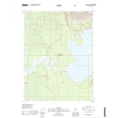
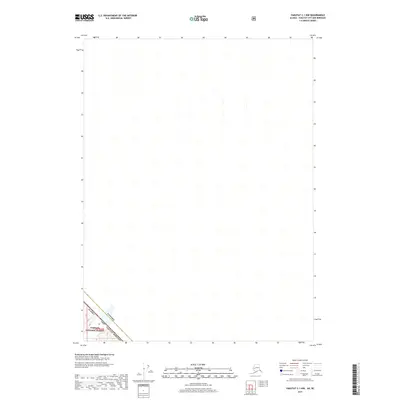
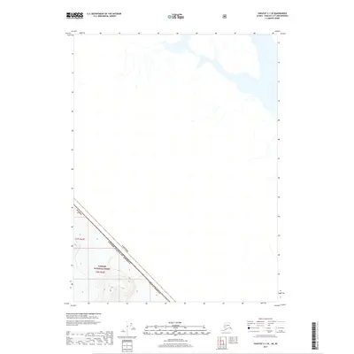
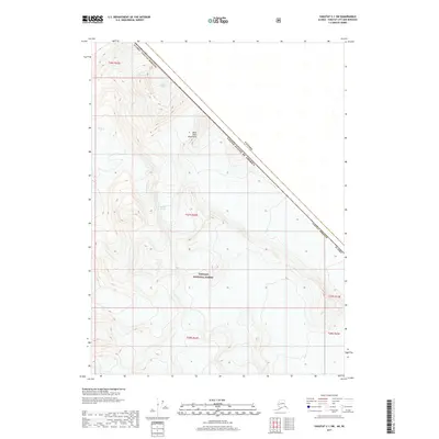
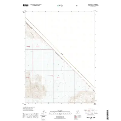
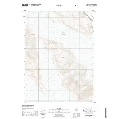
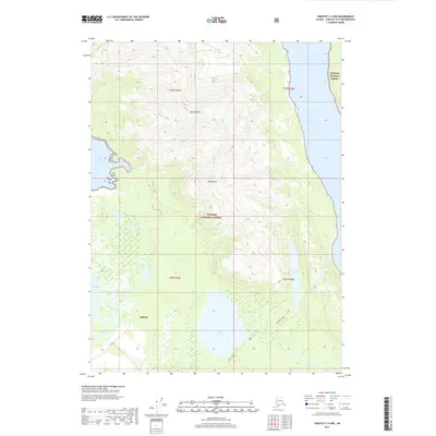
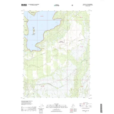
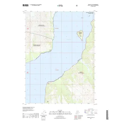
2014 Map of Bering Glacier B-7 NE
USGS Topo · Published 2014About this map
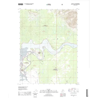
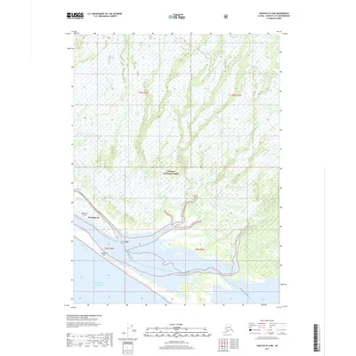
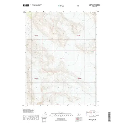
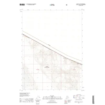
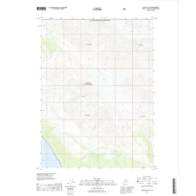
Steller Glacier and Waxell Glacier dominate this glaciated landscape in the coastal mountains of south-central Alaska. The map traces the boundary of the Valdez-Cordova Census Area Yakutat City and Borough, cutting diagonally across the ice fields. This 2014 survey reveals the complex drainage patterns of a high-altitude wilderness where glacial melt feeds into features like Hohlinsock Lake. The southern edge of the sheet captures the massive expanse of the Bering Glacier, illustrating the interconnected nature of these vast ice systems. The terrain is characterized by steep elevation contours that define the ridges separating these slow-moving ice rivers, providing a detailed record of the region's cryosphere before further modern transformations.
Find a feature on this map
12 named features on this map. Tap any name to fly to it.
Don’t see what you’re looking for? This feature index may not catch every label — zoom into the map to look around manually.
Map Details
Editions of this 2014 Bering Glacier B-7 NE Map
This is the sole edition of this map. No revisions or reprints were ever made.
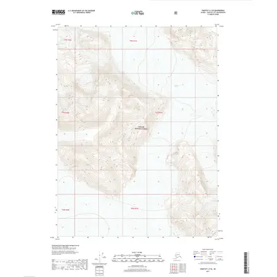
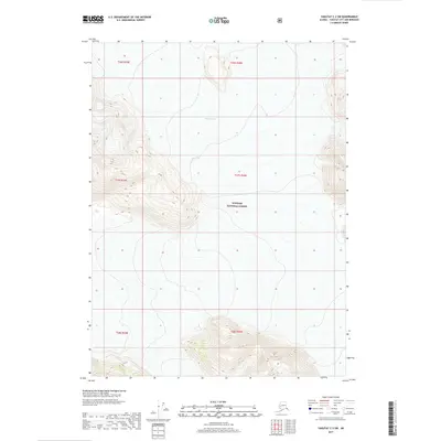
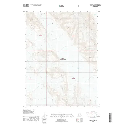
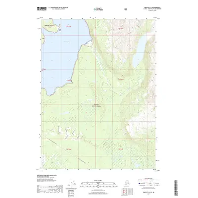
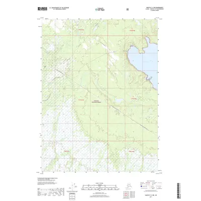
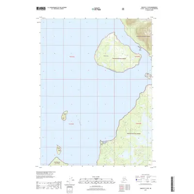
Historical Maps of Unorganized Borough Through Time
343 maps found

1948 Bering Glacier A-4
Yakutat Borough, AK

1948 Icy Bay D-2 and D-3
Yakutat Borough, AK

1950 Bering Glacier A-3
Yakutat Borough, AK

1950 Bering Glacier
Yakutat Borough, AK

1950 Icy Bay
Yakutat Borough, AK

1951 Bering Glacier A-2
Yakutat Borough, AK

1951 Bering Glacier A-4
Yakutat Borough, AK

1951 Bering Glacier
Yakutat Borough, AK

1951 Icy Bay D-2 and D-3
Yakutat Borough, AK

1951 Icy Bay
Yakutat Borough, AK

1951 Mt Saint Elias
Yakutat Borough, AK

1959 Bering Glacier A-2
Yakutat Borough, AK

1959 Bering Glacier A-3
Yakutat Borough, AK

1959 Bering Glacier A-4
Yakutat Borough, AK

1959 Bering Glacier
Yakutat Borough, AK

1959 Icy Bay D-2 and D-3
Yakutat Borough, AK

1959 Mt Saint Elias
Yakutat Borough, AK

1959 Yakutat A-1
Yakutat Borough, AK

1959 Yakutat A-2
Yakutat Borough, AK

1959 Yakutat A-3
Yakutat Borough, AK

1959 Yakutat B-1
Yakutat Borough, AK

1959 Yakutat B-2
Yakutat Borough, AK

1959 Yakutat B-3
Yakutat Borough, AK

1959 Yakutat B-4
Yakutat Borough, AK

1959 Yakutat B-5
Yakutat Borough, AK

1959 Yakutat C-3
Yakutat Borough, AK

1959 Yakutat C-4
Yakutat Borough, AK

1959 Yakutat C-5
Yakutat Borough, AK

1959 Yakutat D-3
Yakutat Borough, AK

1959 Yakutat D-4
Yakutat Borough, AK

1959 Yakutat D-5
Yakutat Borough, AK

1961 Icy Bay
Yakutat Borough, AK

1961 Mount Fairweather D-6
Yakutat Borough, AK

1961 Mount Fairweather D-7
Yakutat Borough, AK

1961 Skagway A-7
Yakutat Borough, AK

1961 Skagway A-8
Yakutat Borough, AK

1961 Skagway B-8
Yakutat Borough, AK

1984 Bering Glacier A-4
Yakutat Borough, AK

1984 Bering Glacier A-5
Yakutat Borough, AK

1984 Bering Glacier A-6
Yakutat Borough, AK

1984 Bering Glacier A-7
Yakutat Borough, AK

1984 Bering Glacier A-8
Yakutat Borough, AK

1985 Bering Glacier A-1
Yakutat Borough, AK

1985 Bering Glacier B-1
Yakutat Borough, AK

1985 Bering Glacier B-2
Yakutat Borough, AK

1985 Bering Glacier B-3
Yakutat Borough, AK

1985 Bering Glacier B-4
Yakutat Borough, AK

1985 Bering Glacier B-5
Yakutat Borough, AK

1985 Bering Glacier B-6
Yakutat Borough, AK

1985 Bering Glacier B-7
Yakutat Borough, AK

1985 Bering Glacier C-3
Yakutat Borough, AK

1985 Bering Glacier C-4
Yakutat Borough, AK

1985 Bering Glacier C-5
Yakutat Borough, AK

1985 Bering Glacier C-6
Yakutat Borough, AK

1985 Icy Bay D-1
Yakutat Borough, AK

1985 Mount Saint Elias A-3
Yakutat Borough, AK

1985 Mount Saint Elias A-4
Yakutat Borough, AK

1985 Mount Saint Elias A-5
Yakutat Borough, AK

1985 Mount Saint Elias A-6
Yakutat Borough, AK

1985 Mount Saint Elias A-7
Yakutat Borough, AK

1985 Mount Saint Elias A-8
Yakutat Borough, AK

1985 Mount Saint Elias B-3
Yakutat Borough, AK

1985 Mount Saint Elias B-4
Yakutat Borough, AK

1985 Mount Saint Elias B-5
Yakutat Borough, AK

1985 Mount Saint Elias B-7
Yakutat Borough, AK

1985 Mount Saint Elias B-8
Yakutat Borough, AK

1985 Yakutat C-1
Yakutat Borough, AK

1985 Yakutat C-2
Yakutat Borough, AK

1985 Yakutat C-6
Yakutat Borough, AK

1985 Yakutat C-7
Yakutat Borough, AK

1985 Yakutat C-8
Yakutat Borough, AK

1985 Yakutat D-2
Yakutat Borough, AK

1985 Yakutat D-6
Yakutat Borough, AK

1985 Yakutat D-7
Yakutat Borough, AK

1985 Yakutat D-8
Yakutat Borough, AK

1987 Yakutat B-4 NW
Yakutat Borough, AK

1987 Yakutat B-5 NE
Yakutat Borough, AK

1987 Yakutat C-4 SE
Yakutat Borough, AK

1987 Yakutat C-4 SW
Yakutat Borough, AK

1987 Yakutat C-5 SE
Yakutat Borough, AK

1987 Yakutat C-5 SW
Yakutat Borough, AK

1996 Yakutat C-5
Yakutat Borough, AK

1997 Yakutat B-1
Yakutat Borough, AK

1997 Yakutat C-4
Yakutat Borough, AK

2014 Bering Glacier A-8 NE
Yakutat Borough, AK

2014 Bering Glacier A-8 OE S NW
Yakutat Borough, AK

2014 Bering Glacier A-8 SE
Yakutat Borough, AK

2014 Bering Glacier A-8 SW
Yakutat Borough, AK

2014 Bering Glacier B-6 NW
Yakutat Borough, AK
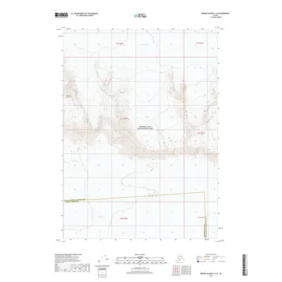
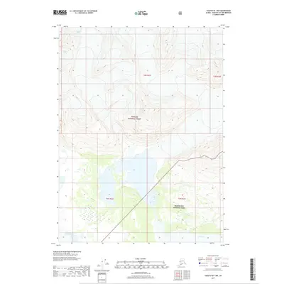
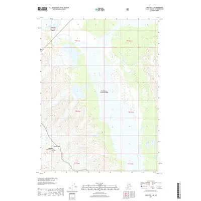
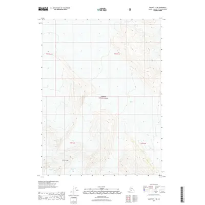
2014 Bering Glacier B-7 NE
Yakutat Borough, AK

2014 Bering Glacier C-6 SW
Yakutat Borough, AK

2016 Bering Glacier A-4 NE
Yakutat Borough, AK

2016 Bering Glacier A-4 NW
Yakutat Borough, AK

2016 Bering Glacier A-4 SE
Yakutat Borough, AK

2016 Bering Glacier A-4 SW
Yakutat Borough, AK

2016 Bering Glacier A-5 NE
Yakutat Borough, AK

2016 Bering Glacier A-5 NW
Yakutat Borough, AK

2016 Bering Glacier A-5 SE
Yakutat Borough, AK

2016 Bering Glacier A-5 SW
Yakutat Borough, AK

2016 Bering Glacier A-6 NE
Yakutat Borough, AK

2016 Bering Glacier A-6 NW
Yakutat Borough, AK

2016 Bering Glacier A-6 SE
Yakutat Borough, AK

2016 Bering Glacier A-6 SW
Yakutat Borough, AK

2016 Bering Glacier A-7 NE
Yakutat Borough, AK

2016 Bering Glacier A-7 NW
Yakutat Borough, AK

2016 Bering Glacier A-7 SE
Yakutat Borough, AK

2016 Bering Glacier A-7 SW
Yakutat Borough, AK

2016 Bering Glacier B-4 NE
Yakutat Borough, AK

2016 Bering Glacier B-4 NW
Yakutat Borough, AK

2016 Bering Glacier B-4 SE
Yakutat Borough, AK

2016 Bering Glacier B-4 SW
Yakutat Borough, AK

2016 Bering Glacier B-5 NE
Yakutat Borough, AK

2016 Bering Glacier B-5 NW
Yakutat Borough, AK

2016 Bering Glacier B-5 SE
Yakutat Borough, AK

2016 Bering Glacier B-5 SW
Yakutat Borough, AK

2016 Bering Glacier B-6 NE
Yakutat Borough, AK

2016 Bering Glacier B-6 SE
Yakutat Borough, AK

2016 Bering Glacier B-6 SW
Yakutat Borough, AK

2016 Bering Glacier B-7 SE
Yakutat Borough, AK

2016 Bering Glacier B-7 SW
Yakutat Borough, AK
2016 Bering Glacier C-4 SE
Yakutat Borough, AK
2016 Bering Glacier C-4 SW
Yakutat Borough, AK
2016 Bering Glacier C-5 SE
Yakutat Borough, AK
2016 Bering Glacier C-5 SW
Yakutat Borough, AK
2016 Bering Glacier C-6 SE
Yakutat Borough, AK

2017 Bering Glacier A-1 NE
Yakutat Borough, AK

2017 Bering Glacier A-1 NW
Yakutat Borough, AK

2017 Bering Glacier A-1 SE
Yakutat Borough, AK

2017 Bering Glacier A-1 SW
Yakutat Borough, AK

2017 Bering Glacier A-2 NE
Yakutat Borough, AK

2017 Bering Glacier A-2 NW
Yakutat Borough, AK

2017 Bering Glacier A-2 SE
Yakutat Borough, AK

2017 Bering Glacier A-2 SW
Yakutat Borough, AK

2017 Bering Glacier A-3 NE
Yakutat Borough, AK

2017 Bering Glacier A-3 NW
Yakutat Borough, AK

2017 Bering Glacier A-3 SE
Yakutat Borough, AK

2017 Bering Glacier A-3 SW
Yakutat Borough, AK

2017 Bering Glacier B-1 NE
Yakutat Borough, AK

2017 Bering Glacier B-1 NW
Yakutat Borough, AK

2017 Bering Glacier B-1 SE
Yakutat Borough, AK

2017 Bering Glacier B-1 SW
Yakutat Borough, AK

2017 Bering Glacier B-2 NE
Yakutat Borough, AK

2017 Bering Glacier B-2 NW
Yakutat Borough, AK

2017 Bering Glacier B-2 SE
Yakutat Borough, AK

2017 Bering Glacier B-2 SW
Yakutat Borough, AK

2017 Bering Glacier B-3 NE
Yakutat Borough, AK

2017 Bering Glacier B-3 NW
Yakutat Borough, AK

2017 Bering Glacier B-3 SE
Yakutat Borough, AK

2017 Bering Glacier B-3 SW
Yakutat Borough, AK
2017 Bering Glacier C-3 SE
Yakutat Borough, AK
2017 Bering Glacier C-3 SW
Yakutat Borough, AK

2017 Icy Bay D-1 NE
Yakutat Borough, AK

2017 Icy Bay D-1 NW
Yakutat Borough, AK

2017 Icy Bay D-1 SE
Yakutat Borough, AK

2017 Icy Bay D-1 SW
Yakutat Borough, AK

2017 Icy Bay D-2 NE
Yakutat Borough, AK

2017 Icy Bay D-2 NW
Yakutat Borough, AK

2017 Icy Bay D-2 SE
Yakutat Borough, AK

2017 Icy Bay D-3 NE
Yakutat Borough, AK

2017 Mount Fairweather D-5 NW
Yakutat Borough, AK

2017 Mount Fairweather D-6 NE
Yakutat Borough, AK

2017 Mount Fairweather D-6 NW
Yakutat Borough, AK

2017 Mount Fairweather D-6 SW
Yakutat Borough, AK

2017 Mount Fairweather D-7 NE
Yakutat Borough, AK

2017 Mount Saint Elias A-4 NE
Yakutat Borough, AK

2017 Mount Saint Elias A-4 NW
Yakutat Borough, AK

2017 Mount Saint Elias A-4 SE
Yakutat Borough, AK

2017 Mount Saint Elias A-4 SW
Yakutat Borough, AK

2017 Mount Saint Elias A-5 NE
Yakutat Borough, AK

2017 Mount Saint Elias A-5 NW
Yakutat Borough, AK

2017 Mount Saint Elias A-5 SE
Yakutat Borough, AK

2017 Mount Saint Elias A-5 SW
Yakutat Borough, AK

2017 Mount Saint Elias A-6 NE
Yakutat Borough, AK

2017 Mount Saint Elias A-6 NW
Yakutat Borough, AK

2017 Mount Saint Elias A-6 SE
Yakutat Borough, AK

2017 Mount Saint Elias A-6 SW
Yakutat Borough, AK

2017 Mount Saint Elias A-7 NE
Yakutat Borough, AK

2017 Mount Saint Elias A-7 NW
Yakutat Borough, AK

2017 Mount Saint Elias A-7 SE
Yakutat Borough, AK

2017 Mount Saint Elias A-7 SW
Yakutat Borough, AK

2017 Mount Saint Elias A-8 NE
Yakutat Borough, AK

2017 Mount Saint Elias A-8 NW
Yakutat Borough, AK

2017 Mount Saint Elias A-8 SE
Yakutat Borough, AK

2017 Mount Saint Elias A-8 SW
Yakutat Borough, AK

2017 Mount Saint Elias B-4 SE
Yakutat Borough, AK

2017 Mount Saint Elias B-4 SW
Yakutat Borough, AK

2017 Mount Saint Elias B-5 SE
Yakutat Borough, AK

2017 Mount Saint Elias B-5 SW
Yakutat Borough, AK

2017 Mount Saint Elias B-7 OE E SW
Yakutat Borough, AK

2017 Mount Saint Elias B-7 SE
Yakutat Borough, AK

2017 Mount Saint Elias B-7 SW
Yakutat Borough, AK

2017 Mount Saint Elias B-8 SE
Yakutat Borough, AK

2017 Mount Saint Elias B-8 SW
Yakutat Borough, AK

2017 Yakutat A-1 NE
Yakutat Borough, AK
2017 Yakutat A-1 NW
Yakutat Borough, AK

2017 Yakutat A-1 SE
Yakutat Borough, AK

2017 Yakutat A-1 SW
Yakutat Borough, AK
2017 Yakutat A-2 NE
Yakutat Borough, AK
2017 Yakutat A-2 NW
Yakutat Borough, AK

2017 Yakutat A-2 SE
Yakutat Borough, AK
2017 Yakutat A-2 SW
Yakutat Borough, AK
2017 Yakutat A-3 NE
Yakutat Borough, AK
2017 Yakutat B-1 NE
Yakutat Borough, AK
2017 Yakutat B-1 NW
Yakutat Borough, AK

2017 Yakutat B-1 SE
Yakutat Borough, AK
2017 Yakutat B-1 SW
Yakutat Borough, AK
2017 Yakutat B-2 NE
Yakutat Borough, AK
2017 Yakutat B-2 NW
Yakutat Borough, AK
2017 Yakutat B-2 SE
Yakutat Borough, AK
2017 Yakutat B-2 SW
Yakutat Borough, AK
2017 Yakutat B-3 NE
Yakutat Borough, AK
2017 Yakutat B-3 NW
Yakutat Borough, AK
2017 Yakutat B-3 SE
Yakutat Borough, AK
2017 Yakutat B-3 SW
Yakutat Borough, AK
2017 Yakutat B-4 NE
Yakutat Borough, AK
2017 Yakutat B-4 NW
Yakutat Borough, AK
2017 Yakutat B-4 SE
Yakutat Borough, AK
2017 Yakutat B-4 SW
Yakutat Borough, AK

2017 Yakutat B-5 NE
Yakutat Borough, AK
2017 Yakutat B-5 NW
Yakutat Borough, AK
2017 Yakutat C-1 NW
Yakutat Borough, AK
2017 Yakutat C-1 SE
Yakutat Borough, AK
2017 Yakutat C-1 SW
Yakutat Borough, AK
2017 Yakutat C-2 NE
Yakutat Borough, AK
2017 Yakutat C-2 NW
Yakutat Borough, AK
2017 Yakutat C-2 SE
Yakutat Borough, AK
2017 Yakutat C-2 SW
Yakutat Borough, AK
2017 Yakutat C-3 NE
Yakutat Borough, AK
2017 Yakutat C-3 NW
Yakutat Borough, AK
2017 Yakutat C-3 SE
Yakutat Borough, AK
2017 Yakutat C-3 SW
Yakutat Borough, AK
2017 Yakutat C-4 NE
Yakutat Borough, AK
2017 Yakutat C-4 NW
Yakutat Borough, AK
2017 Yakutat C-4 SE
Yakutat Borough, AK
2017 Yakutat C-4 SW
Yakutat Borough, AK
2017 Yakutat C-5 NE
Yakutat Borough, AK
2017 Yakutat C-5 SE
Yakutat Borough, AK
2017 Yakutat C-5 SW
Yakutat Borough, AK

2017 Yakutat C-6 NW
Yakutat Borough, AK

2017 Yakutat C-7 NE
Yakutat Borough, AK

2017 Yakutat C-7 NW
Yakutat Borough, AK

2017 Yakutat C-8 NE
Yakutat Borough, AK

2017 Yakutat C-8 NW
Yakutat Borough, AK
2017 Yakutat D-2 NW
Yakutat Borough, AK
2017 Yakutat D-2 SW
Yakutat Borough, AK
2017 Yakutat D-3 NE
Yakutat Borough, AK
2017 Yakutat D-3 NW
Yakutat Borough, AK
2017 Yakutat D-3 SE
Yakutat Borough, AK
2017 Yakutat D-3 SW
Yakutat Borough, AK
2017 Yakutat D-4 NE
Yakutat Borough, AK
2017 Yakutat D-4 NW
Yakutat Borough, AK
2017 Yakutat D-4 SE
Yakutat Borough, AK
2017 Yakutat D-4 SW
Yakutat Borough, AK
2017 Yakutat D-5 NE
Yakutat Borough, AK

2017 Yakutat D-5 NW
Yakutat Borough, AK
2017 Yakutat D-5 SE
Yakutat Borough, AK

2017 Yakutat D-5 SW
Yakutat Borough, AK

2017 Yakutat D-6 NE
Yakutat Borough, AK

2017 Yakutat D-6 NW
Yakutat Borough, AK

2017 Yakutat D-6 SE
Yakutat Borough, AK

2017 Yakutat D-6 SW
Yakutat Borough, AK

2017 Yakutat D-7 NE
Yakutat Borough, AK

2017 Yakutat D-7 NW
Yakutat Borough, AK

2017 Yakutat D-7 SE
Yakutat Borough, AK

2017 Yakutat D-7 SW
Yakutat Borough, AK

2017 Yakutat D-8 NE
Yakutat Borough, AK

2017 Yakutat D-8 NW
Yakutat Borough, AK

2017 Yakutat D-8 SE
Yakutat Borough, AK

2017 Yakutat D-8 SW
Yakutat Borough, AK

2018 Bering Glacier A-8 OE S NE
Yakutat Borough, AK

2018 Mount Saint Elias A-3 NW
Yakutat Borough, AK

2018 Mount Saint Elias A-3 SW
Yakutat Borough, AK

2018 Mount Saint Elias B-3 SW
Yakutat Borough, AK

2018 Yakutat A-3 NW
Yakutat Borough, AK

2021 Skagway A-7 NW
Yakutat Borough, AK

2021 Skagway A-7 SW
Yakutat Borough, AK

2021 Skagway A-8 NE
Yakutat Borough, AK

2021 Skagway A-8 NW
Yakutat Borough, AK

2021 Skagway A-8 SE
Yakutat Borough, AK

2021 Skagway A-8 SW
Yakutat Borough, AK

2021 Skagway B-8 NW
Yakutat Borough, AK

2021 Skagway B-8 OE E SW
Yakutat Borough, AK

2021 Skagway B-8 SE
Yakutat Borough, AK

2021 Skagway B-8 SW
Yakutat Borough, AK

2021 Yakutat A-1 NW
Yakutat Borough, AK

2021 Yakutat A-2 NE
Yakutat Borough, AK

2021 Yakutat A-2 NW
Yakutat Borough, AK

2021 Yakutat A-2 SW
Yakutat Borough, AK

2021 Yakutat A-3 NE
Yakutat Borough, AK

2021 Yakutat B-1 NE
Yakutat Borough, AK

2021 Yakutat B-1 NW
Yakutat Borough, AK

2021 Yakutat B-1 SW
Yakutat Borough, AK

2021 Yakutat B-2 NE
Yakutat Borough, AK

2021 Yakutat B-2 NW
Yakutat Borough, AK

2021 Yakutat B-2 SE
Yakutat Borough, AK

2021 Yakutat B-2 SW
Yakutat Borough, AK

2021 Yakutat B-3 NE
Yakutat Borough, AK

2021 Yakutat B-3 NW
Yakutat Borough, AK

2021 Yakutat B-3 SE
Yakutat Borough, AK

2021 Yakutat B-3 SW
Yakutat Borough, AK

2021 Yakutat B-4 NE
Yakutat Borough, AK

2021 Yakutat B-4 NW
Yakutat Borough, AK

2021 Yakutat B-4 SE
Yakutat Borough, AK

2021 Yakutat B-4 SW
Yakutat Borough, AK

2021 Yakutat B-5 NE
Yakutat Borough, AK

2021 Yakutat B-5 NW
Yakutat Borough, AK

2021 Yakutat C-1 NW
Yakutat Borough, AK

2021 Yakutat C-1 SE
Yakutat Borough, AK

2021 Yakutat C-1 SW
Yakutat Borough, AK

2021 Yakutat C-2 NE
Yakutat Borough, AK

2021 Yakutat C-2 NW
Yakutat Borough, AK

2021 Yakutat C-2 SE
Yakutat Borough, AK

2021 Yakutat C-2 SW
Yakutat Borough, AK

2021 Yakutat C-3 NE
Yakutat Borough, AK

2021 Yakutat C-3 NW
Yakutat Borough, AK

2021 Yakutat C-3 SE
Yakutat Borough, AK

2021 Yakutat C-3 SW
Yakutat Borough, AK

2021 Yakutat C-4 NE
Yakutat Borough, AK

2021 Yakutat C-4 NW
Yakutat Borough, AK

2021 Yakutat C-4 SE
Yakutat Borough, AK

2021 Yakutat C-4 SW
Yakutat Borough, AK

2021 Yakutat C-5 NE
Yakutat Borough, AK

2021 Yakutat C-5 SE
Yakutat Borough, AK

2021 Yakutat C-5 SW
Yakutat Borough, AK

2021 Yakutat D-2 NW
Yakutat Borough, AK

2021 Yakutat D-2 SW
Yakutat Borough, AK

2021 Yakutat D-3 NE
Yakutat Borough, AK

2021 Yakutat D-3 NW
Yakutat Borough, AK

2021 Yakutat D-3 SE
Yakutat Borough, AK

2021 Yakutat D-3 SW
Yakutat Borough, AK

2021 Yakutat D-4 NE
Yakutat Borough, AK

2021 Yakutat D-4 NW
Yakutat Borough, AK

2021 Yakutat D-4 SE
Yakutat Borough, AK

2021 Yakutat D-4 SW
Yakutat Borough, AK

2021 Yakutat D-5 NE
Yakutat Borough, AK

2021 Yakutat D-5 SE
Yakutat Borough, AK

2024 Bering Glacier C-3 SE
Yakutat Borough, AK

2024 Bering Glacier C-3 SW
Yakutat Borough, AK

2024 Bering Glacier C-4 SE
Yakutat Borough, AK

2024 Bering Glacier C-4 SW
Yakutat Borough, AK

2024 Bering Glacier C-5 SE
Yakutat Borough, AK

2024 Bering Glacier C-5 SW
Yakutat Borough, AK

2024 Bering Glacier C-6 SE
Yakutat Borough, AK