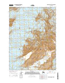
2014 Map of Bering Glacier B-7 NW
USGS Topo · Published 2014About this map
The Chugach Mountains dominate this glacial landscape along the coast of Alaska, where ice and topography define the terrain. The massive Steller Glacier flows through the western portion of the map, while the Waxell Glacier appears in the northeast and southeast corners, illustrating the complex drainage of the regional ice fields. High elevations are punctuated by the Khitrov Hills, rising between the glacial lobes. At the southern edge of the survey, Lake Sofron sits at the terminus of these ice flows, representing a dynamic environment of meltwater and shifting shorelines. This 2014 representation of the Bering Glacier B-7 NW area reveals a workspace of natural forces where human infrastructure is entirely absent in favor of monumental geological and hydrological features.
Find a feature on this map
9 named features on this map. Tap any name to fly to it.
Don’t see what you’re looking for? This feature index may not catch every label — zoom into the map to look around manually.
Map Details
Editions of this 2014 Bering Glacier B-7 NW Map
This is the sole edition of this map. No revisions or reprints were ever made.
Other maps of this area

1950 · Bering Glacier
USGS Topo · 1:250,000

1951 · Bering Glacier
USGS Topo · 1:250,000

1959 · Bering Glacier
USGS Topo · 1:250,000
1985 · Bering Glacier C-7
USGS Topo · 1:63,360
1985 · Bering Glacier B-8
USGS Topo · 1:63,360
1985 · Bering Glacier B-7
USGS Topo · 1:63,360
1985 · Bering Glacier C-8
USGS Topo · 1:63,360
2014 · Bering Glacier C-8 SE
USGS Topo · 1:25,000
2014 · Bering Glacier B-7 NE
USGS Topo · 1:25,000
2014 · Bering Glacier C-7 SE
USGS Topo · 1:25,000