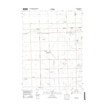
2013 Map of Berkey
USGS Topo · Published 2013About this map
Berkey and Richfield Center sit at the heart of this borderland landscape where Northwest Ohio meets Southeast Michigan. The geography is defined by a dense grid of rural roads and the meandering path of Tenmile Cr, which threads through agricultural fields and small clusters of settlement. Small communities like Raab Corners, Southland, and Frankfort provide a window into the residential patterns of the early 21st century. The area is notable for its numerous consecrated grounds, including Wolfinger Cem and the Immaculate Conception Catholic Cem, which serve as vital landmarks for local genealogical research. Aviation history is represented by small landing strips such as R C Ford Field Airport and Sattler Landing Strip Airport, reflecting the region's continued use of private airfields alongside its established township roads.
Find a feature on this map
77 named features on this map. Tap any name to fly to it.
Don’t see what you’re looking for? This feature index may not catch every label — zoom into the map to look around manually.
Map Details
Editions of this 2013 Berkey Map
This is the sole edition of this map. No revisions or reprints were ever made.
Other maps of this area

1900 · Toledo
USGS Topo · 1:62,500

1911 · Swanton
USGS Topo · 1:62,500

1912 · Dundee
USGS Topo · 1:62,500

1914 · Swanton
USGS Topo · 1:62,500

1926 · Dundee
USGS Topo · 1:62,500

1935 · Whitehouse
USGS Topo · 1:24,000

1935 · Maumee
USGS Topo · 1:24,000

1935 · Berkey
USGS Topo · 1:24,000
1937 · Sylvania
USGS Topo · 1:31,680
1938 · Maumee
USGS Topo · 1:31,680