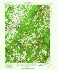
1923 Map of Berlin
USGS Topo · Published 1962About this map
Allegheny Mountain and Savage Mountain dominate this 1923 topographic landscape, defining a region where industry and geography are closely intertwined. The Baltimore and Ohio RR cuts through the high ridges, serving coal operations like the Shipley Bros Mine and Salco Mines. This survey captures a network of small, family-centric communities and rural schoolhouses such as Sandy Hollow Sch and Waggaman Sch that once dotted the Glades Valley.
Find a feature on this map
97 named features on this map. Tap any name to fly to it.
Don’t see what you’re looking for? This feature index may not catch every label — zoom into the map to look around manually.
Map Details
Editions of this 1923 Berlin Map
3 editions found

Other maps of this area

1898 · Frostburg
USGS Topo · 1:62,500

1899 · Flintstone
USGS Topo · 1:62,500

1899 · Grantsville
USGS Topo · 1:62,500

1900 · Flintstone
USGS Topo · 1:62,500

1901 · Frostburg
USGS Topo · 1:62,500

1904 · Grantsville
USGS Topo · 1:62,500

1908 · Frostburg
USGS Topo · 1:62,500

1908 · Bedford
USGS Topo · 1:62,500

1910 · Bedford
USGS Topo · 1:62,500

1913 · Somerset
USGS Topo · 1:62,500