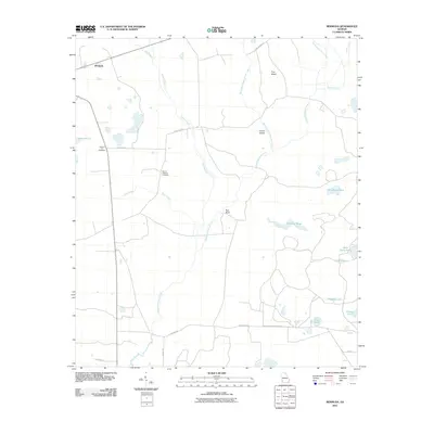
2011 Map of Bermuda
USGS Topo · Published 2011About this map
The settlement of Bermuda and the surrounding agricultural lands of Calhoun County define this landscape, where family history is anchored at sites like Pleasant Hill Cemetery and Mount Pleasant Cemetery. The area is characterized by an intricate drainage system dominated by Chickasawhatchee Creek and its various tributaries, including Spring Creek and Keel Creek. The topography features subtle rises such as Pine Island, Jones Island, and Red Bluff, which emerge from a terrain dotted with numerous named water bodies. From the expansive White Pond in the west to the cluster of lakes in the southeast, including Alligator Lake, Liar Lake, and Clear Lake, the map reveals a water-rich environment. Local transit is managed via a network of rural roads like Pine Island Rd and Jericho Rd, which connect the scattered farms and homesteads across the Georgia coastal plain.
Find a feature on this map
26 named features on this map. Tap any name to fly to it.
Don’t see what you’re looking for? This feature index may not catch every label — zoom into the map to look around manually.
Map Details
Editions of this 2011 Bermuda Map
This is the sole edition of this map. No revisions or reprints were ever made.
Other maps of this area

1953 · Dothan
USGS Topo · 1:250,000

1954 · Dothan
USGS Topo · 1:250,000

1955 · Dothan
USGS Topo · 1:250,000

1956 · Newton
USGS Topo · 1:62,500

1956 · Sasser
USGS Topo · 1:62,500

1973 · Morgan
USGS Topo · 1:24,000

1973 · Pretoria
USGS Topo · 1:24,000
1973 · Holt
USGS Topo · 1:24,000

1974 · Elmodel
USGS Topo · 1:24,000
1974 · Newton
USGS Topo · 1:24,000