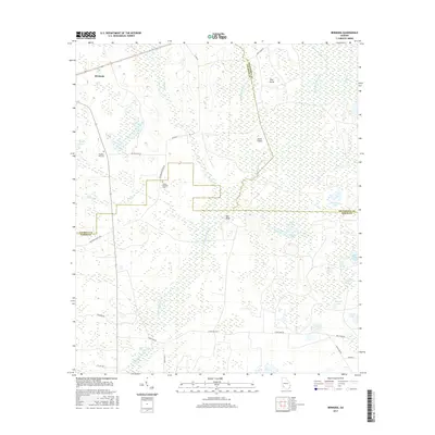
2017 Map of Bermuda
USGS Topo · Published 2017About this map
Chickasawhatchee Creek flows through a complex network of wetlands and small settlements at the junction of Calhoun, Dougherty, and Baker Counties. The small community of Bermuda sits in the northwest, while the landscape further south is defined by the extensive Hellgate Swamp and Hellgate Pond. This era of the landscape is marked by numerous family and community landmarks, such as Pleasant Hill Cem and Mount Pleasant Cem, reflecting the deep-rooted local history of this rural corner of Southwest Georgia.
Find a feature on this map
39 named features on this map. Tap any name to fly to it.
Don’t see what you’re looking for? This feature index may not catch every label — zoom into the map to look around manually.
Map Details
Editions of this 2017 Bermuda Map
This is the sole edition of this map. No revisions or reprints were ever made.
Other maps of this area

1953 · Dothan
USGS Topo · 1:250,000

1954 · Dothan
USGS Topo · 1:250,000

1955 · Dothan
USGS Topo · 1:250,000

1956 · Newton
USGS Topo · 1:62,500

1956 · Sasser
USGS Topo · 1:62,500

1973 · Morgan
USGS Topo · 1:24,000

1973 · Pretoria
USGS Topo · 1:24,000
1973 · Holt
USGS Topo · 1:24,000

1974 · Elmodel
USGS Topo · 1:24,000
1974 · Newton
USGS Topo · 1:24,000