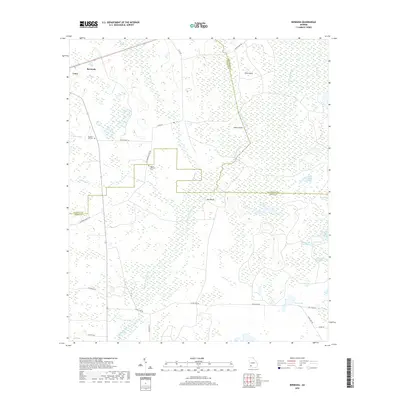
2020 Map of Bermuda
USGS Topo · Published 2020About this map
The settlement of Bermuda and the nearby town of Leary define the northwestern corner of this Southwest Georgia landscape, where the border of Calhoun, Baker, and Dougherty counties meet. The terrain is characterized by a complex network of wetlands and ephemeral water bodies, most notably the meandering Chickasawhatchee Creek and the expansive Hellgate Swamp. For local historians and genealogists, the presence of Mt Pleasant Ch and the associated Mount Pleasant Cem, along with Pleasant Hill Cem, provides specific points of interest for family research. The eastern half of the map is dominated by named wetlands such as Fortysecond Street Swamp and Twentythird Street Swamp, interspersed with distinctive local landmarks like Liar Lake, Alligator Lake, and Bird Roost Pond. This 2020 update traces the modern road network, including Co RD 40 and Clear Lake Rd, as they navigate around the numerous ponds and islands like Jones Island and Pine Island.
Find a feature on this map
40 named features on this map. Tap any name to fly to it.
Don’t see what you’re looking for? This feature index may not catch every label — zoom into the map to look around manually.
Map Details
Editions of this 2020 Bermuda Map
This is the sole edition of this map. No revisions or reprints were ever made.
Other maps of this area

1953 · Dothan
USGS Topo · 1:250,000

1954 · Dothan
USGS Topo · 1:250,000

1955 · Dothan
USGS Topo · 1:250,000

1956 · Newton
USGS Topo · 1:62,500

1956 · Sasser
USGS Topo · 1:62,500

1973 · Morgan
USGS Topo · 1:24,000

1973 · Pretoria
USGS Topo · 1:24,000
1973 · Holt
USGS Topo · 1:24,000

1974 · Elmodel
USGS Topo · 1:24,000
1974 · Newton
USGS Topo · 1:24,000