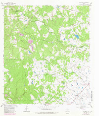
1958 Map of Bernardo
USGS Topo · Published 1982About this map
The San Bernard River winds across the landscape, marking the boundary between Austin and Colorado Counties. This 1958 survey, updated with 1978 aerial revisions, shows a rural landscape where small family names and community anchors define the map. Near the settlement of Mentz, St Rochs Ch serves as a local landmark, while to the southeast, the village of Bernardo is home to the Bernardo Sch. The map is particularly rich for genealogists, identifying numerous small family-named burial grounds like Gaedeke Cem, Reinhardt Cem, and Hinks Cem. Industrial activity is concentrated in the north at the New Ulm Oil Field and along the Missouri Kansas Texas railroad line, while the drainage of Hayes Creek and Schmitt Creek shapes the wooded terrain.
Find a feature on this map
28 named features on this map. Tap any name to fly to it.
Don’t see what you’re looking for? This feature index may not catch every label — zoom into the map to look around manually.
Map Details
Editions of this 1958 Bernardo Map
2 editions found
Other maps of this area

1919 · Fayettsville
USGS Topo · 1:62,500

1953 · Seguin
USGS Topo · 1:250,000

1956 · Bellville
USGS Topo · 1:62,500

1956 · Glidden
USGS Topo · 1:62,500

1957 · Eagle Lake
USGS Topo · 1:62,500

1957 · Columbus
USGS Topo · 1:24,000

1958 · Seguin
USGS Topo · 1:250,000

1958 · Industry
USGS Topo · 1:24,000

1958 · Frelsburg
USGS Topo · 1:24,000

1958 · Bernardo
USGS Topo · 1:24,000