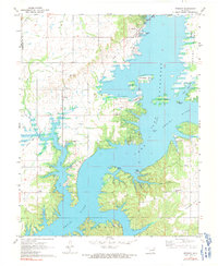
1971 Map of Bernice
USGS Topo · Published 1991About this map
Lake O' the Cherokees dominates the landscape of Delaware County, Oklahoma, in this early 1970s survey. The map details a complex shoreline where the Neosho River and Duck Creek meet, highlighting the conversion of the river valley into a major reservoir. On the western shore, the community of Cleora is shown with its local Cleora Sch, while Bernice sits at the northern edge near Bernice Point. The rugged geography of the reservoir is marked by numerous islands, including the large Monkey Island and smaller features like Goat Island and Rabbit Island. Historical footprints are visible in the Old Railroad Grade and Old Grade winding through the hills. Several family-named burial grounds, such as Wallen Cem and Hilderbrand Cem, provide essential data for genealogists tracing local residents near Sweetwater Prairie.
Find a feature on this map
31 named features on this map. Tap any name to fly to it.
Don’t see what you’re looking for? This feature index may not catch every label — zoom into the map to look around manually.
Map Details
Editions of this 1971 Bernice Map
2 editions found
Other maps of this area

1896 · Pryor
USGS Topo · 1:125,000

1899 · Siloam Springs
USGS Topo · 1:125,000

1901 · Vinita
USGS Topo · 1:125,000

1901 · Pryor
USGS Topo · 1:125,000

1903 · Siloam Springs
USGS Topo · 1:125,000

1904 · Siloam Springs
USGS Topo · 1:125,000

1907 · Wyandotte
USGS Topo · 1:125,000

1909 · Wyandotte
USGS Topo · 1:125,000

1913 · Vinita
USGS Topo · 1:125,000

1954 · Tulsa
USGS Topo · 1:250,000