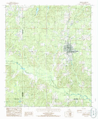
1985 Map of Bernice
USGS Topo · Published 1986About this map
The town of Bernice serves as the primary hub in this north Louisiana landscape, characterized by the winding path of Middle Fork Bayou D'Arbonne and its many tributaries. Photographed in the early 1980s, the map reveals a region defined by parish boundaries and timbered terrain where the Union Parish Lincoln Parish and Claiborne Parish Union Parish lines meet. Small-scale industrial activity is evident in the scattered Gravel Pits and a Sludge Pit found in the western hills.
Find a feature on this map
19 named features on this map. Tap any name to fly to it.
Don’t see what you’re looking for? This feature index may not catch every label — zoom into the map to look around manually.
Map Details
Editions of this 1985 Bernice Map
This is the sole edition of this map. No revisions or reprints were ever made.
Other maps of this area

1950 · Ruston
USGS Topo · 1:62,500

1950 · Arcadia
USGS Topo · 1:62,500

1951 · Arcadia
USGS Topo · 1:62,500

1951 · Ruston
USGS Topo · 1:62,500

1951 · Summerfield
USGS Topo · 1:62,500

1951 · Bernice
USGS Topo · 1:62,500

1955 · Shreveport
USGS Topo · 1:250,000

1956 · Shreveport
USGS Topo · 1:250,000

1984 · Shreveport
USGS Topo · 1:250,000

1985 · Monroe North
USGS Topo · 1:100,000