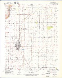
1978 Map of Bernie
USGS Topo · Published 1979About this map
The town of Bernie serves as the focal point of this Southeast Missouri landscape in the late 1970s, situated at a critical junction of drainage engineering and rail transport. The St Louis Southwestern Railroad railroad corridor bisects the terrain, mirroring the strictly partitioned agricultural blocks of Liberty and Elk townships. This survey illustrates the intricate water management system of the Bootheel region, where the Main Ditch, Bess Slough, and several numbered channels like No 4 Ditch reclaim the lowland for cultivation.
Find a feature on this map
19 named features on this map. Tap any name to fly to it.
Don’t see what you’re looking for? This feature index may not catch every label — zoom into the map to look around manually.
Map Details
Editions of this 1978 Bernie Map
This is the sole edition of this map. No revisions or reprints were ever made.
Other maps of this area

1934 · Bloomfield
USGS Topo · 1:62,500

1934 · Puxico
USGS Topo · 1:62,500

1939 · Bloomfield
USGS Topo · 1:62,500

1939 · Puxico
USGS Topo · 1:62,500

1940 · Malden
USGS Topo · 1:62,500

1940 · Valley Ridge
USGS Topo · 1:62,500

1949 · Bloomfield
USGS Topo · 1:62,500

1956 · Valley Ridge
USGS Topo · 1:62,500

1956 · Malden
USGS Topo · 1:62,500

1956 · Dyersburg
USGS Topo · 1:250,000