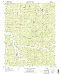
1978 Map of Berryman
USGS Topo · Published 1990About this map
Mark Twain National Forest dominates this landscape in the late 1970s, where the rural settlement of Berryman sits at the junction of rugged Ozark terrain and conservation land. The topography is defined by intricate drainage systems such as Courtois Creek and Lost Creek, which are fed by numerous hollows including Smith Mill Hollow and Henpeck Hollow. For genealogists and local historians, the presence of Courtois Cem, Criswell Cem, and Oak Grove Ch Cem provides essential spatial context for ancestral homesteads near Cedar Ridge and Shirley Ridge. The area's shift toward public recreation is evident through the development of the Berryman Trail, the Edward Beecher Recreation Area, and multiple campgrounds like Harmon Spring Campground and Brazil Creek Campground, reflecting a transition from traditional Ozark subsistence toward forestry and outdoor tourism.
Find a feature on this map
34 named features on this map. Tap any name to fly to it.
Don’t see what you’re looking for? This feature index may not catch every label — zoom into the map to look around manually.
Map Details
Editions of this 1978 Berryman Map
4 editions found
Other maps of this area

1901 · De Soto
USGS Topo · 1:125,000

1903 · Sullivan
USGS Topo · 1:125,000

1906 · Potosi
USGS Topo · 1:62,500

1943 · Berryman
USGS Topo · 1:62,500

1945 · Berryman
USGS Topo · 1:62,500

1946 · Richwoods
USGS Topo · 1:62,500

1947 · Sullivan
USGS Topo · 1:62,500

1948 · Richwoods
USGS Topo · 1:62,500

1949 · Saint Louis
USGS Topo · 1:250,000

1949 · Sullivan
USGS Topo · 1:62,500