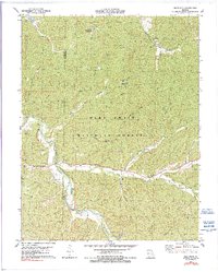
1978 Map of Berryman
USGS Topo · Published 1990About this map
The Berryman settlement serves as a focal point for this landscape in the late 1970s, situated at the boundary of Crawford Co and Washington Co. This rural Missouri terrain is defined by the winding course of Courtois Creek and the protective canopy of the Mark Twain National Forest. The map documents a scattered community structure typical of the Ozark region, where family legacies are marked by small cemeteries such as Courtois Cem, Dobkins Cem, and Criswell Cem.
Find a feature on this map
32 named features on this map. Tap any name to fly to it.
Don’t see what you’re looking for? This feature index may not catch every label — zoom into the map to look around manually.
Map Details
Editions of this 1978 Berryman Map
4 editions found
Other maps of this area

1901 · De Soto
USGS Topo · 1:125,000

1903 · Sullivan
USGS Topo · 1:125,000

1906 · Potosi
USGS Topo · 1:62,500

1943 · Berryman
USGS Topo · 1:62,500

1945 · Berryman
USGS Topo · 1:62,500

1946 · Richwoods
USGS Topo · 1:62,500

1947 · Sullivan
USGS Topo · 1:62,500

1948 · Richwoods
USGS Topo · 1:62,500

1949 · Saint Louis
USGS Topo · 1:250,000

1949 · Sullivan
USGS Topo · 1:62,500