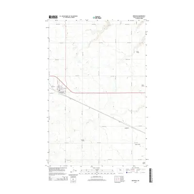
2014 Map of Berthold
USGS Topo · Published 2014About this map
Berthold sits as a primary junction in Ward County, where the grid of the North Dakota plains is punctuated by a series of geographic coulees. The town's street-level detail, including Central Ave E and Main St N, reflects its role as a local center for the surrounding agricultural community. To the west, the Wild Rose Cem provides a point of genealogical interest for local researchers. The landscape is defined by drainage features such as Blacks Coulee in the north and Tasker Coulee in the southeast, which carve into the otherwise steady elevation of the high prairie. Farther south, the small settlement of Lonetree marks a point along CR-10, showing the distributed nature of rural habitation in this portion of the state.
Find a feature on this map
32 named features on this map. Tap any name to fly to it.
Don’t see what you’re looking for? This feature index may not catch every label — zoom into the map to look around manually.
Map Details
Editions of this 2014 Berthold Map
This is the sole edition of this map. No revisions or reprints were ever made.
Other maps of this area

1949 · Hartland
USGS Topo · 1:24,000

1949 · Carpio NE
USGS Topo · 1:24,000

1949 · Carpio
USGS Topo · 1:24,000

1950 · Des Lacs
USGS Topo · 1:24,000

1954 · Minot
USGS Topo · 1:250,000

1958 · Minot
USGS Topo · 1:250,000

1980 · Minot
USGS Topo · 1:100,000

1980 · Rice Lake NW
USGS Topo · 1:24,000

1980 · Tagus SE
USGS Topo · 1:24,000
1980 · Berthold
USGS Topo · 1:24,000