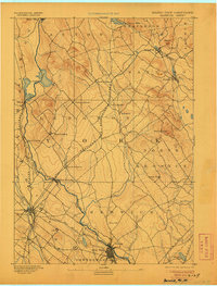
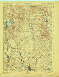
1893 Map of Berwick
USGS Topo · Published 1906About this map
Salmon Falls River serves as the primary geographical anchor and political boundary on this late 19th-century survey of the Maine and New Hampshire borderlands. The landscape is defined by a dense network of industrial and transport infrastructure, particularly the complex intersections of the Boston and Maine Railroad and the Portland and Rochester Railroad. These rail lines facilitated the growth of numerous concentrated settlements such as Great Falls, Rochester, and Sanford.
Find a feature on this map
44 named features on this map. Tap any name to fly to it.
Don’t see what you’re looking for? This feature index may not catch every label — zoom into the map to look around manually.
Map Details
Editions of this 1893 Berwick Map
6 editions found
Other maps of this area

1891 · Berwick
USGS Topo · 1:62,500

1891 · Kennebunk
USGS Topo · 1:62,500

1891 · Buxton
USGS Topo · 1:62,500

1891 · Newfield
USGS Topo · 1:62,500

1892 · Buxton
USGS Topo · 1:62,500

1893 · Kennebunk
USGS Topo · 1:62,500

1893 · Dover
USGS Topo · 1:62,500

1893 · Berwick
USGS Topo · 1:62,500

1893 · York
USGS Topo · 1:62,500

1893 · Buxton
USGS Topo · 1:62,500