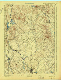
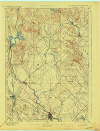
1893 Map of Berwick
USGS Topo · Published 1925About this map
The Maine New Hampshire Boundary Line follows the winding course of the Salmon Falls River, separating industrial and agricultural hubs at the end of the nineteenth century. This reconnaissance survey, led by Marcus Baker, illustrates a landscape deeply integrated with the rail networks of the day. The Portland and Rochester Railroad cuts diagonally across the center, connecting the various villages of Lebanon, while the Boston and Maine Railroad services the busy corridor near Rochester and Gonic. Distinctive peaks like Bauneg Beg and Beaver Hill rise above the river valleys, where settlements such as Sanford and Springvale sit along the Mousam River. For those tracing local history, the map provides a clear picture of the rural post offices and small crossings that once defined these border towns before modern road systems reshaped the region.
Find a feature on this map
42 named features on this map. Tap any name to fly to it.
Don’t see what you’re looking for? This feature index may not catch every label — zoom into the map to look around manually.
Map Details
Editions of this 1893 Berwick Map
6 editions found
Other maps of this area

1891 · Berwick
USGS Topo · 1:62,500

1891 · Kennebunk
USGS Topo · 1:62,500

1891 · Buxton
USGS Topo · 1:62,500

1891 · Newfield
USGS Topo · 1:62,500

1892 · Buxton
USGS Topo · 1:62,500

1893 · Kennebunk
USGS Topo · 1:62,500

1893 · Dover
USGS Topo · 1:62,500

1893 · Berwick
USGS Topo · 1:62,500

1893 · York
USGS Topo · 1:62,500

1893 · Buxton
USGS Topo · 1:62,500