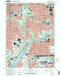
1993 Map of Berwyn
USGS Topo · Published 1993About this map
The dense industrial and residential fabric of western Chicago and its immediate suburbs defines this 1993 study, where the Chicago Sanitary and Ship Canal and the Des Plaines River corridor anchor a landscape of transit and utilities. The map illustrates the massive footprint of Midway Airport in the east, while the western reaches are dominated by sprawling institutional complexes like the Hines VA Hospital and Loyola University Medical Ctr.
Find a feature on this map
128 named features on this map. Tap any name to fly to it.
Don’t see what you’re looking for? This feature index may not catch every label — zoom into the map to look around manually.
Map Details
Editions of this 1993 Berwyn Map
2 editions found
Other maps of this area

1889 · Chicago
USGS Topo · 1:62,500

1890 · Des Plaines
USGS Topo · 1:62,500

1891 · Chicago
USGS Topo · 1:62,500

1891 · Riverside
USGS Topo · 1:62,500

1892 · Calumet
USGS Topo · 1:62,500

1893 · Calumet
USGS Topo · 1:62,500

1893 · Riverside
USGS Topo · 1:62,500

1894 · Des Plaines
USGS Topo · 1:62,500

1900 · Chicago
USGS Topo · 1:62,500

1900 · Des Plaines
USGS Topo · 1:62,500