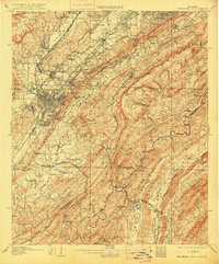
1907 Map of Bessemer Iron District
USGS Topo · Published 1915About this map
Red Mountain and Shades Mountain anchor this 1905 survey, illustrating the industrial pulse of the Birmingham district. The landscape is defined by the dense network of the Alabama Great Southern RR, the Louisville and Nashville RR, and the Electric RR, which connected burgeoning industrial hubs like Bessemer, Ensley, and Dolomite. This era represents the height of the regional iron boom, where rail lines weave through gaps in the ridges to reach settlements such as Wheeling, Grasselli, and Raimund. Beyond the heavy industry, the map documents a network of community centers like Pleasant Ridge Church, Hopewell Church, and the settlement of Jonesboro. The geography of the Jones Valley and Opossum Valley shows how the terrain dictated the placement of mines, mills, and the residential pockets that served them.
Find a feature on this map
135 named features on this map. Tap any name to fly to it.
Don’t see what you’re looking for? This feature index may not catch every label — zoom into the map to look around manually.
Map Details
Editions of this 1907 Bessemer Iron District Map
4 editions found

Other maps of this area

1889 · Birmingham
USGS Topo · 1:125,000

1890 · Bessemer
USGS Topo · 1:125,000

1892 · Birmingham
USGS Topo · 1:125,000

1892 · Bessemer
USGS Topo · 1:125,000

1893 · Jasper
USGS Topo · 1:125,000

1895 · Birmingham
USGS Topo · 1:125,000

1899 · Brookwood
USGS Topo · 1:125,000

1904 · Birmingham Coal District
USGS Topo · 1:62,500

1905 · Bessemer Iron District
USGS Topo · 1:62,500

1905 · Leeds
USGS Topo · 1:62,500