
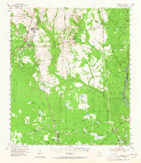
1955 Map of Bessmay
USGS Topo · Published 1956About this map
Bessmay and Buna anchor the northwest corner of this mid-1950s landscape, where the lumber and rail industries meet the deep bottomlands of the Sabine River basin. The area is defined by a dense network of watercourses and wetlands, including the sprawling Little Cypress Creek and distinct geographical features like Bumpy Baygall and Devils Pocket. Resource extraction is evident through numerous Oil Wells and Gas Wells scattered across the prairies, illustrating the mid-century industrial footprint on the East Texas piney woods.
Find a feature on this map
60 named features on this map. Tap any name to fly to it.
Don’t see what you’re looking for? This feature index may not catch every label — zoom into the map to look around manually.
Map Details
Editions of this 1955 Bessmay Map
2 editions found
Other maps of this area

1926 · Lakeview
USGS Topo · 1:24,000

1926 · Texla
USGS Topo · 1:24,000

1926 · Mauriceville
USGS Topo · 1:24,000

1932 · Beaumont
USGS Topo · 1:62,500

1932 · Orange
USGS Topo · 1:62,500

1943 · Mauriceville
USGS Topo · 1:24,000

1943 · Texla
USGS Topo · 1:24,000

1947 · Starks
USGS Topo · 1:31,680

1947 · Toomey
USGS Topo · 1:31,680

1947 · Carter Creek
USGS Topo · 1:31,680