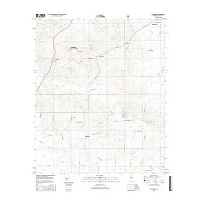
2015 Map of Betheden
USGS Topo · Published 2015About this map
Tombigbee National Forest dominates the upper-left landscape of this survey, defining a rural stretch of Winston County where small settlements like Betheden and Webster serve as local anchors. The area is heavily intersected by creek systems, including Mill Cr and the headwaters of Nanih Waiya Cr, which flow through a terrain marked by a network of family-named roads such as Marshall Dawkins Rd and Gerald Dempsey Rd.
Find a feature on this map
64 named features on this map. Tap any name to fly to it.
Don’t see what you’re looking for? This feature index may not catch every label — zoom into the map to look around manually.
Map Details
Editions of this 2015 Betheden Map
This is the sole edition of this map. No revisions or reprints were ever made.
Other maps of this area

1953 · West Point
USGS Topo · 1:250,000

1958 · West Point
USGS Topo · 1:250,000

1963 · West Point
USGS Topo · 1:250,000

1965 · Bluff Lake
USGS Topo · 1:24,000

1965 · Bradley
USGS Topo · 1:24,000

1972 · Louisville North
USGS Topo · 1:24,000
1972 · Louisville South
USGS Topo · 1:24,000

1972 · Sturgis
USGS Topo · 1:24,000
1973 · Boon
USGS Topo · 1:24,000
1973 · Fearns Springs
USGS Topo · 1:24,000