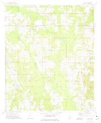
1973 Map of Boon
USGS Topo · Published 1975About this map
Boon and Cork anchor this rural Winston County landscape in the early 1970s, an area defined by its dense network of community churches and small-scale resource extraction. The map reveals a high concentration of spiritual centers such as Zion Chapel, New Hope Ch, and Rocky Hill Ch, which likely served as the primary social hubs for surrounding farmsteads. The local economy is visibly tied to the land, evidenced by a Claypit, Sandpit, and a Gravel Pit scattered across the terrain. Hydrology is dominated by the meandering paths of Nanih Waiya Creek and Town Creek, while the presence of Murphy Creek Ch near its namesake Murphy Creek suggests how early settlement patterns followed these vital waterways. This survey provides a clear look at the intersection of religious life and geography in central Mississippi before modern development further altered the rural road network.
Find a feature on this map
19 named features on this map. Tap any name to fly to it.
Don’t see what you’re looking for? This feature index may not catch every label — zoom into the map to look around manually.
Map Details
Editions of this 1973 Boon Map
2 editions found
Other maps of this area

1953 · Meridian
USGS Topo · 1:250,000

1953 · West Point
USGS Topo · 1:250,000

1957 · Meridian
USGS Topo · 1:250,000

1958 · West Point
USGS Topo · 1:250,000

1962 · Vernon
USGS Topo · 1:24,000

1962 · Preston
USGS Topo · 1:24,000

1963 · West Point
USGS Topo · 1:250,000

1965 · Meridian
USGS Topo · 1:250,000

1972 · Louisville North
USGS Topo · 1:24,000
1972 · Noxapater
USGS Topo · 1:24,000