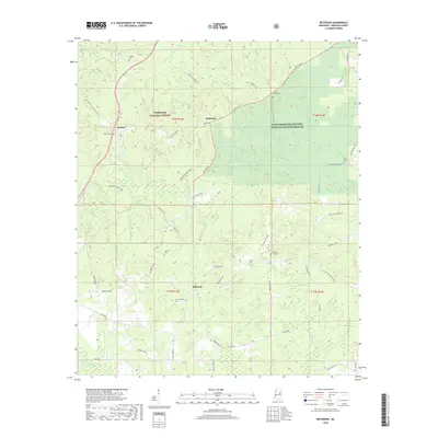
2018 Map of Betheden
USGS Topo · Published 2018About this map
The Tombigbee National Forest and the Sam D Hamilton Noxubee National Wildlife Refuge dominate the landscape of Winston County in this modern survey. The small community of Betheden sits at a crossroads, surrounded by numerous historic burial grounds that speak to the long-standing family roots in the area. Genealogists will find interest in locations such as Antioch Cem, Liberty Cem, and Oliver Cem. The terrain is defined by a dense network of streams, including Nanih Waiya Cr and Miller Cr, which drain the timbered uplands. Local transport relies on winding rural routes like Betheden Rd and Brooksville Rd, connecting the scattered settlements of Webster and Millcreek to the surrounding conservation lands. This map highlights the intersection of public forest management and rural Mississippi life in the late twenty-first century.
Find a feature on this map
58 named features on this map. Tap any name to fly to it.
Don’t see what you’re looking for? This feature index may not catch every label — zoom into the map to look around manually.
Map Details
Editions of this 2018 Betheden Map
This is the sole edition of this map. No revisions or reprints were ever made.
Other maps of this area

1953 · West Point
USGS Topo · 1:250,000

1958 · West Point
USGS Topo · 1:250,000

1963 · West Point
USGS Topo · 1:250,000

1965 · Bluff Lake
USGS Topo · 1:24,000

1965 · Bradley
USGS Topo · 1:24,000

1972 · Louisville North
USGS Topo · 1:24,000
1972 · Louisville South
USGS Topo · 1:24,000

1972 · Sturgis
USGS Topo · 1:24,000
1973 · Boon
USGS Topo · 1:24,000
1973 · Fearns Springs
USGS Topo · 1:24,000