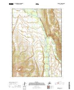
2019 Map of Bethel D-1 NE
USGS Topo · Published 2019About this map
Aniak River meanders through this interior Alaska landscape, defining the central drainage pattern as it flows across several townships including t10n r55w. The river's serpentine path is flanked by the rising slopes of the surrounding hills, where Atsaksouluk Creek feeds into the valley system from the east. This 2019 survey captures the wilderness character of the Bethel Census Area, illustrating the complex hydrology of the Kuskokwim River watershed before any modern infrastructure development reached this specific reach of the back-country. The topography is dominated by steep-sided ridges and narrow stream valleys, characteristic of the transition from the river lowlands to the more elevated interior highlands.
Find a feature on this map
8 named features on this map. Tap any name to fly to it.
Don’t see what you’re looking for? This feature index may not catch every label — zoom into the map to look around manually.
Map Details
Editions of this 2019 Bethel D-1 NE Map
This is the sole edition of this map. No revisions or reprints were ever made.
Other maps of this area

1947 · Russian Mission
USGS Topo · 1:250,000

1950 · Russian Mission
USGS Topo · 1:250,000

1950 · Sleetmute
USGS Topo · 1:250,000

1950 · Bethel
USGS Topo · 1:250,000

1950 · Taylor Mountains
USGS Topo · 1:250,000

1951 · Taylor Mountains
USGS Topo · 1:250,000

1954 · Sleetmute
USGS Topo · 1:250,000

1954 · Taylor Mountains
USGS Topo · 1:250,000

1954 · Taylor Mountains D-8
USGS Topo · 1:63,360
1954 · Sleetmute A-8
USGS Topo · 1:63,360