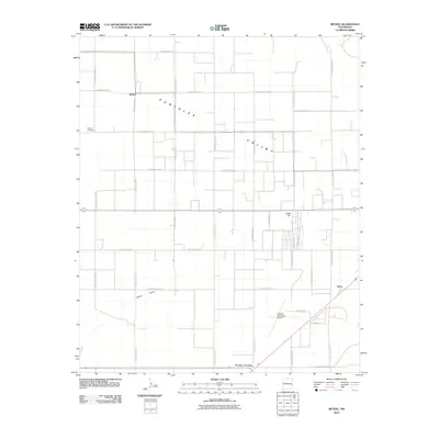
2010 Map of Bethel
USGS Topo · Published 2010About this map
Portales Valley defines this agricultural landscape in Roosevelt County, where a rigid grid of South Roosevelt Roads organizes the high plains terrain. The settlement of Bethel serves as a local anchor in the northwest, supported by the Bethel Cemetery. The map captures a moment in the early 21st century when rural life revolves around these dispersed junctions and the vital water drainage of Boone Draw, which cuts across the southern portion of the quadrangle.
Find a feature on this map
30 named features on this map. Tap any name to fly to it.
Don’t see what you’re looking for? This feature index may not catch every label — zoom into the map to look around manually.
Map Details
Editions of this 2010 Bethel Map
This is the sole edition of this map. No revisions or reprints were ever made.
Other maps of this area

1954 · Clovis
USGS Topo · 1:250,000

1957 · Portair
USGS Topo · 1:62,500

1957 · Melrose
USGS Topo · 1:62,500

1957 · Portales
USGS Topo · 1:62,500

1958 · Clovis
USGS Topo · 1:250,000

1973 · Floyd
USGS Topo · 1:24,000

1973 · Floyd SE
USGS Topo · 1:24,000
1973 · Melrose SE
USGS Topo · 1:24,000
1985 · Portales SE
USGS Topo · 1:24,000
1985 · Delphos
USGS Topo · 1:24,000