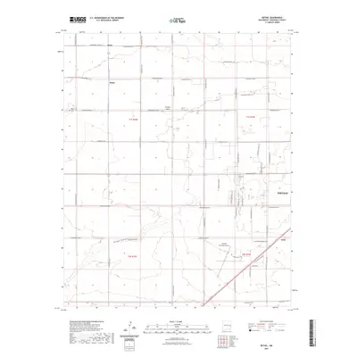
2023 Map of Bethel
USGS Topo · Published 2023About this map
Portales Valley defines the agricultural heart of this Roosevelt County landscape, where the settlements of Floyd and Bethel anchor a grid of rural roads and homesteads. The topography is marked by subtle rises like Chalk Hill and the seasonal path of Boone Draw, which cuts through the southern portion of the quadrangle. Local history is centered around the Bethel Cem and the residential expansion evident in Highlands and Moores Manors. The map captures the infrastructure supporting the region, from the Portales Municipal Airport to the small rail siding at Yerba in the southeast. This survey reflects the persistent rectilinear organization of the High Plains, where nearly every section is accessible by designated routes like S Roosevelt Road 1 and S Roosevelt Road AB.
Find a feature on this map
43 named features on this map. Tap any name to fly to it.
Don’t see what you’re looking for? This feature index may not catch every label — zoom into the map to look around manually.
Map Details
Editions of this 2023 Bethel Map
This is the sole edition of this map. No revisions or reprints were ever made.
Other maps of this area

1954 · Clovis
USGS Topo · 1:250,000

1957 · Portair
USGS Topo · 1:62,500

1957 · Melrose
USGS Topo · 1:62,500

1957 · Portales
USGS Topo · 1:62,500

1958 · Clovis
USGS Topo · 1:250,000

1973 · Floyd
USGS Topo · 1:24,000

1973 · Floyd SE
USGS Topo · 1:24,000
1973 · Melrose SE
USGS Topo · 1:24,000
1985 · Portales SE
USGS Topo · 1:24,000
1985 · Delphos
USGS Topo · 1:24,000