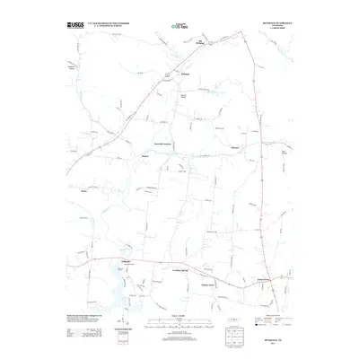
2013 Map of Bethpage
USGS Topo · Published 2013About this map
Castalian Springs anchors the southern portion of this landscape, a historic mineral spring site that helped shape the settlement of Sumner County. The area is defined by the winding course of Bledsoe Cr and its various tributaries like Lick Cr and Brush Fork. The transition between agricultural lands and more modern developments is evident in the cluster of small communities and distinct landmarks like the Red Chief Orchard and Shady Cove Resort near Oakland. Moving north, the map reveals a corridor of rural junctions and small settlements including Rogana, Hartsville Junction, and Bethpage. The relationship between the terrain and transportation is clear as roads follow the natural contours of Mutton Hollow and the base of Green Mountain. This survey documents the local-scale geography of Tennessee's Central Basin as it appeared in the early 21st century, preserving the locations of rural commerce sites like Paynes Store.
Find a feature on this map
108 named features on this map. Tap any name to fly to it.
Don’t see what you’re looking for? This feature index may not catch every label — zoom into the map to look around manually.
Map Details
Editions of this 2013 Bethpage Map
This is the sole edition of this map. No revisions or reprints were ever made.
Other maps of this area

1931 · Lafayette
USGS Topo · 1:62,500

1931 · Adolphus
USGS Topo · 1:62,500

1942 · Gallatin
USGS Topo · 1:100,000

1955 · Bethpage
USGS Topo · 1:24,000

1955 · Laguardo
USGS Topo · 1:24,000

1955 · Hunters Point
USGS Topo · 1:24,000

1955 · Gallatin
USGS Topo · 1:24,000

1956 · Nashville
USGS Topo · 1:250,000

1958 · Westmoreland
USGS Topo · 1:24,000
1958 · Fountain Head
USGS Topo · 1:24,000